You are here: Home > Network List > US - United States National Seismic Network Stations List
> Station ERPA Erie, Pennsylvania, USA > Earthquake Result Viewer
ERPA Erie, Pennsylvania, USA - Earthquake Result Viewer
| Earthquake location: |
Near Coast Of Northern Chile |
| Earthquake latitude/longitude: |
-27.0/-71.0 |
| Earthquake time(UTC): |
2006/04/30 (120) 19:17:17 GMT |
| Earthquake Depth: |
27 km |
| Earthquake Magnitude: |
6.0 MB, 6.4 MS, 6.7 MW, 6.6 MW |
| Earthquake Catalog/Contributor: |
WHDF/NEIC |
|
| Network: |
US United States National Seismic Network |
| Station: |
ERPA Erie, Pennsylvania, USA |
| Lat/Lon: |
42.12 N/79.99 W |
| Elevation: |
306 m |
|
| Distance: |
69.3 deg |
| Az: |
352.828 deg |
| Baz: |
171.391 deg |
| Ray Param: |
0.05571055 |
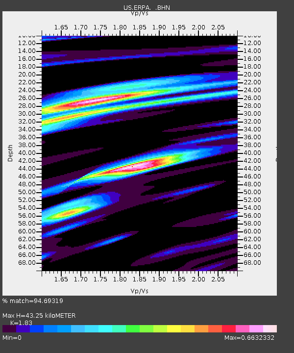
| Estimated Moho Depth: |
43.25 km |
| Estimated Crust Vp/Vs: |
1.83 |
| Assumed Crust Vp: |
6.419 km/s |
| Estimated Crust Vs: |
3.508 km/s |
| Estimated Crust Poisson's Ratio: |
0.29 |
|
| Radial Match: |
94.69319 % |
| Radial Bump: |
347 |
| Transverse Match: |
84.16632 % |
| Transverse Bump: |
400 |
| SOD ConfigId: |
2669 |
| Insert Time: |
2010-03-05 01:12:18.702 +0000 |
| GWidth: |
2.5 |
| Max Bumps: |
400 |
| Tol: |
0.001 |
|

Signal To Noise
| Channel | StoN | STA | LTA |
| US:ERPA: :BHN:20060430T19:27:50.960999Z | 2.031058 | 2.21813E-7 | 1.09210575E-7 |
| US:ERPA: :BHE:20060430T19:27:50.960999Z | 1.5248395 | 1.6732655E-7 | 1.09733875E-7 |
| US:ERPA: :BHZ:20060430T19:27:50.960999Z | 3.3185403 | 6.164326E-7 | 1.8575415E-7 |
| Arrivals |
| Ps | 5.8 SECOND |
| PpPs | 18 SECOND |
| PsPs/PpSs | 24 SECOND |


