You are here: Home > Network List > US - United States National Seismic Network Stations List
> Station ERPA Erie, Pennsylvania, USA > Earthquake Result Viewer
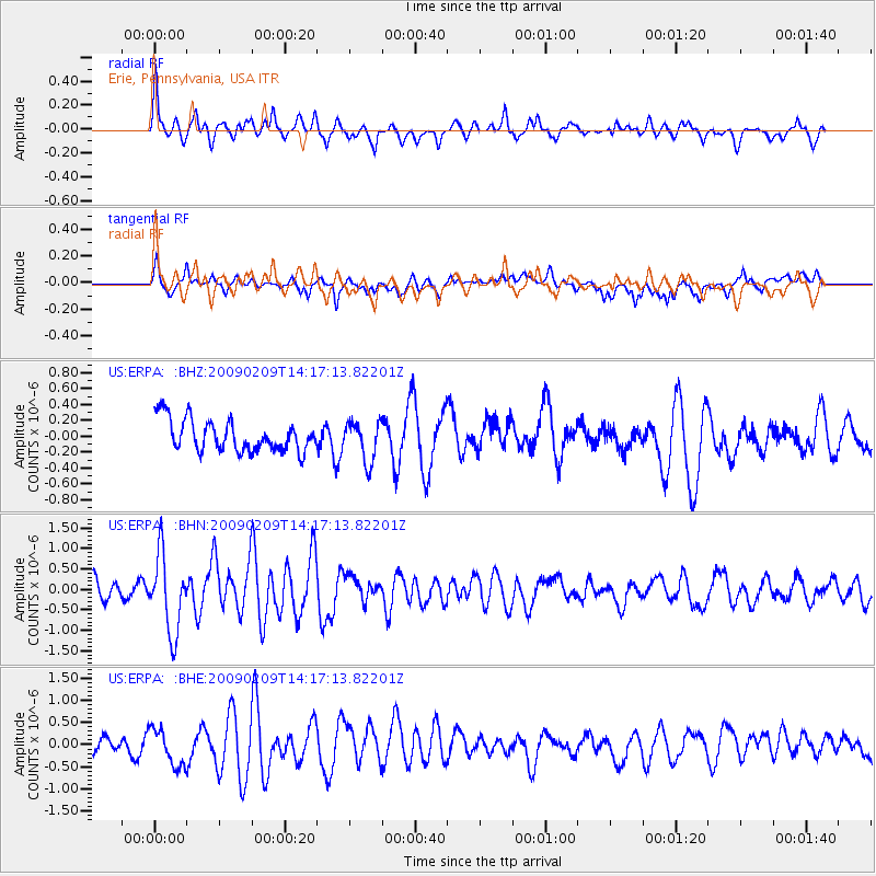
ERPA Erie, Pennsylvania, USA - Earthquake Result Viewer
*The percent match for this event was below the threshold and hence no stack was calculated.
| Earthquake location: |
Near Coast Of Northern Peru |
| Earthquake latitude/longitude: |
-6.6/-81.2 |
| Earthquake time(UTC): |
2009/02/09 (040) 14:09:02 GMT |
| Earthquake Depth: |
15 km |
| Earthquake Magnitude: |
5.5 MB, 5.5 MS, 6.0 MW, 5.9 MW |
| Earthquake Catalog/Contributor: |
WHDF/NEIC |
|
| Network: |
US United States National Seismic Network |
| Station: |
ERPA Erie, Pennsylvania, USA |
| Lat/Lon: |
42.12 N/79.99 W |
| Elevation: |
306 m |
|
| Distance: |
48.5 deg |
| Az: |
1.154 deg |
| Baz: |
181.541 deg |
| Ray Param: |
$rayparam |
*The percent match for this event was below the threshold and hence was not used in the summary stack. |
|
| Radial Match: |
60.72887 % |
| Radial Bump: |
349 |
| Transverse Match: |
62.818096 % |
| Transverse Bump: |
400 |
| SOD ConfigId: |
2658 |
| Insert Time: |
2010-03-05 01:12:40.599 +0000 |
| GWidth: |
2.5 |
| Max Bumps: |
400 |
| Tol: |
0.001 |
|
Signal To Noise
| Channel | StoN | STA | LTA |
| US:ERPA: :BHN:20090209T14:17:13.82201Z | 3.6996758 | 9.3648396E-7 | 2.5312596E-7 |
| US:ERPA: :BHE:20090209T14:17:13.82201Z | 1.6074035 | 4.2269542E-7 | 2.6296783E-7 |
| US:ERPA: :BHZ:20090209T14:17:13.82201Z | 1.2649928 | 2.5134443E-7 | 1.9869236E-7 |
| Arrivals |
| Ps | |
| PpPs | |
| PsPs/PpSs | |


