You are here: Home > Network List > TA - USArray Transportable Network (new EarthScope stations) Stations List
> Station MDND Maddock, ND, USA > Earthquake Result Viewer
MDND Maddock, ND, USA - Earthquake Result Viewer
*The percent match for this event was below the threshold and hence no stack was calculated.
| Earthquake location: |
Rat Islands, Aleutian Islands |
| Earthquake latitude/longitude: |
51.8/176.6 |
| Earthquake time(UTC): |
2016/04/11 (102) 20:10:35 GMT |
| Earthquake Depth: |
22 km |
| Earthquake Magnitude: |
5.6 MB, 5.5 MB, 5.6 MI |
| Earthquake Catalog/Contributor: |
NEIC PDE/NEIC COMCAT |
|
| Network: |
TA USArray Transportable Network (new EarthScope stations) |
| Station: |
MDND Maddock, ND, USA |
| Lat/Lon: |
47.85 N/99.60 W |
| Elevation: |
479 m |
|
| Distance: |
51.3 deg |
| Az: |
59.068 deg |
| Baz: |
307.81 deg |
| Ray Param: |
$rayparam |
*The percent match for this event was below the threshold and hence was not used in the summary stack. |
|
| Radial Match: |
44.07707 % |
| Radial Bump: |
400 |
| Transverse Match: |
65.23559 % |
| Transverse Bump: |
400 |
| SOD ConfigId: |
7422571 |
| Insert Time: |
2019-04-22 05:10:40.225 +0000 |
| GWidth: |
2.5 |
| Max Bumps: |
400 |
| Tol: |
0.001 |
|
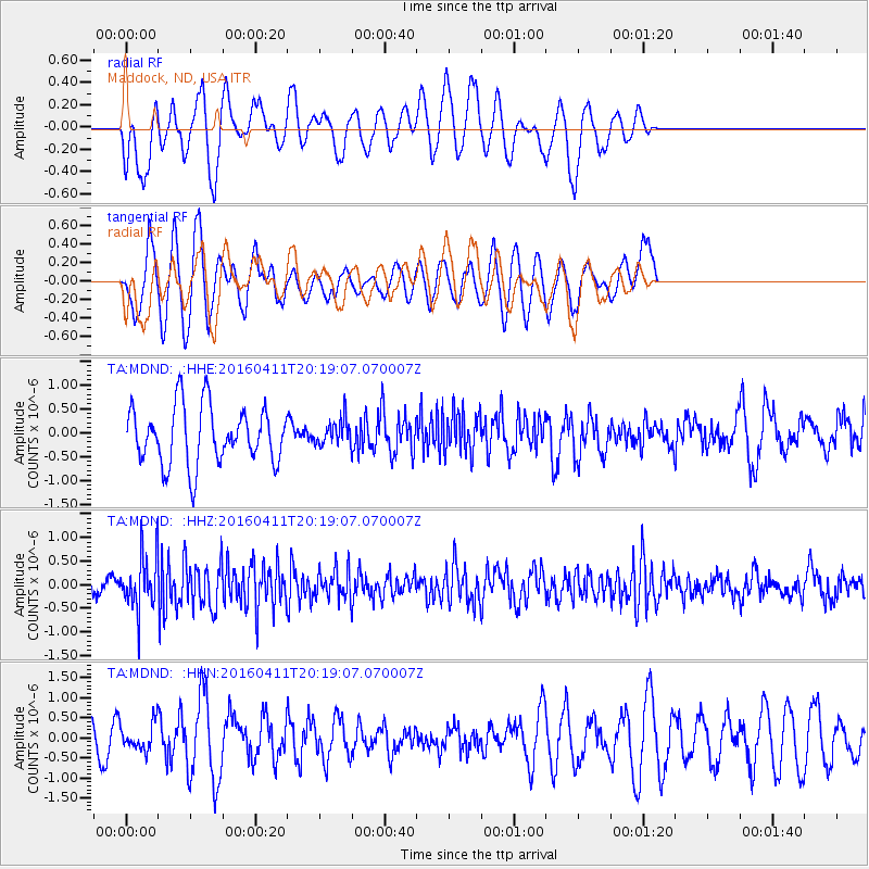
Signal To Noise
| Channel | StoN | STA | LTA |
| TA:MDND: :HHZ:20160411T20:19:07.070007Z | 4.1427593 | 5.8750254E-7 | 1.4181431E-7 |
| TA:MDND: :HHN:20160411T20:19:07.070007Z | 0.7165162 | 3.4582547E-7 | 4.826485E-7 |
| TA:MDND: :HHE:20160411T20:19:07.070007Z | 0.4854257 | 2.9256987E-7 | 6.027078E-7 |
| Arrivals |
| Ps | |
| PpPs | |
| PsPs/PpSs | |


