You are here: Home > Network List > US - United States National Seismic Network Stations List
> Station ERPA Erie, Pennsylvania, USA > Earthquake Result Viewer
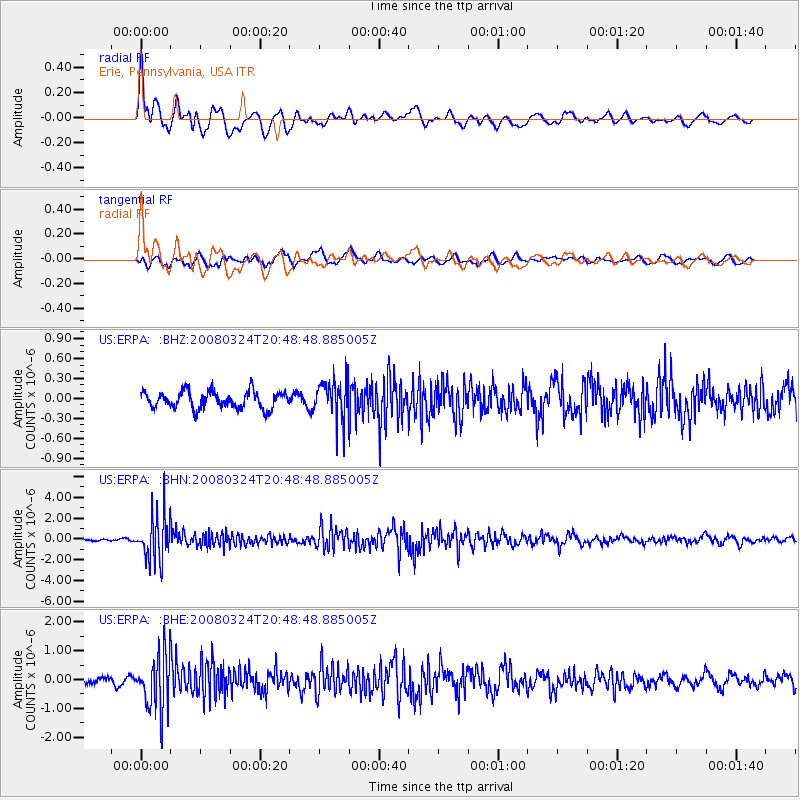
ERPA Erie, Pennsylvania, USA - Earthquake Result Viewer
*The percent match for this event was below the threshold and hence no stack was calculated.
| Earthquake location: |
Chile-Bolivia Border Region |
| Earthquake latitude/longitude: |
-20.0/-69.0 |
| Earthquake time(UTC): |
2008/03/24 (084) 20:39:07 GMT |
| Earthquake Depth: |
120 km |
| Earthquake Magnitude: |
5.7 MB, 6.2 MW, 6.1 MW |
| Earthquake Catalog/Contributor: |
WHDF/NEIC |
|
| Network: |
US United States National Seismic Network |
| Station: |
ERPA Erie, Pennsylvania, USA |
| Lat/Lon: |
42.12 N/79.99 W |
| Elevation: |
306 m |
|
| Distance: |
62.7 deg |
| Az: |
350.784 deg |
| Baz: |
168.323 deg |
| Ray Param: |
$rayparam |
*The percent match for this event was below the threshold and hence was not used in the summary stack. |
|
| Radial Match: |
76.82158 % |
| Radial Bump: |
400 |
| Transverse Match: |
48.862644 % |
| Transverse Bump: |
400 |
| SOD ConfigId: |
2504 |
| Insert Time: |
2010-03-05 01:12:55.006 +0000 |
| GWidth: |
2.5 |
| Max Bumps: |
400 |
| Tol: |
0.001 |
|
Signal To Noise
| Channel | StoN | STA | LTA |
| US:ERPA: :BHN:20080324T20:48:48.885005Z | 23.869747 | 2.1964954E-6 | 9.202005E-8 |
| US:ERPA: :BHE:20080324T20:48:48.885005Z | 8.107056 | 9.884694E-7 | 1.2192706E-7 |
| US:ERPA: :BHZ:20080324T20:48:48.885005Z | 2.3625996 | 2.9507007E-7 | 1.2489211E-7 |
| Arrivals |
| Ps | |
| PpPs | |
| PsPs/PpSs | |


