You are here: Home > Network List > US - United States National Seismic Network Stations List
> Station ERPA Erie, Pennsylvania, USA > Earthquake Result Viewer
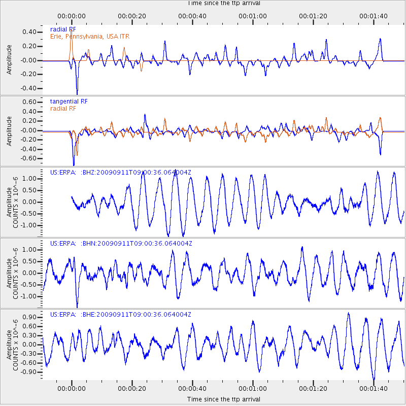
ERPA Erie, Pennsylvania, USA - Earthquake Result Viewer
*The percent match for this event was below the threshold and hence no stack was calculated.
| Earthquake location: |
Kuril Islands |
| Earthquake latitude/longitude: |
48.3/154.2 |
| Earthquake time(UTC): |
2009/09/11 (254) 08:49:11 GMT |
| Earthquake Depth: |
35 km |
| Earthquake Magnitude: |
5.8 MB, 5.0 MS, 5.6 MW, 5.6 MW |
| Earthquake Catalog/Contributor: |
WHDF/NEIC |
|
| Network: |
US United States National Seismic Network |
| Station: |
ERPA Erie, Pennsylvania, USA |
| Lat/Lon: |
42.12 N/79.99 W |
| Elevation: |
306 m |
|
| Distance: |
78.1 deg |
| Az: |
38.092 deg |
| Baz: |
326.377 deg |
| Ray Param: |
$rayparam |
*The percent match for this event was below the threshold and hence was not used in the summary stack. |
|
| Radial Match: |
57.710724 % |
| Radial Bump: |
400 |
| Transverse Match: |
58.325012 % |
| Transverse Bump: |
400 |
| SOD ConfigId: |
2622 |
| Insert Time: |
2010-03-05 01:13:14.573 +0000 |
| GWidth: |
2.5 |
| Max Bumps: |
400 |
| Tol: |
0.001 |
|
Signal To Noise
| Channel | StoN | STA | LTA |
| US:ERPA: :BHN:20090911T09:00:36.064004Z | 1.4260315 | 5.736872E-7 | 4.0229634E-7 |
| US:ERPA: :BHE:20090911T09:00:36.064004Z | 1.0366877 | 3.1229501E-7 | 3.012431E-7 |
| US:ERPA: :BHZ:20090911T09:00:36.064004Z | 2.0916111 | 9.4875253E-7 | 4.535989E-7 |
| Arrivals |
| Ps | |
| PpPs | |
| PsPs/PpSs | |


