You are here: Home > Network List > US - United States National Seismic Network Stations List
> Station ERPA Erie, Pennsylvania, USA > Earthquake Result Viewer
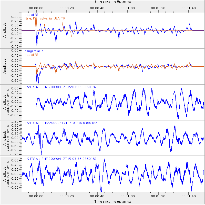
ERPA Erie, Pennsylvania, USA - Earthquake Result Viewer
*The percent match for this event was below the threshold and hence no stack was calculated.
| Earthquake location: |
Kuril Islands |
| Earthquake latitude/longitude: |
46.2/151.7 |
| Earthquake time(UTC): |
2009/04/17 (107) 14:51:58 GMT |
| Earthquake Depth: |
49 km |
| Earthquake Magnitude: |
5.5 MB, 5.0 MS, 5.7 MW, 5.6 MW |
| Earthquake Catalog/Contributor: |
WHDF/NEIC |
|
| Network: |
US United States National Seismic Network |
| Station: |
ERPA Erie, Pennsylvania, USA |
| Lat/Lon: |
42.12 N/79.99 W |
| Elevation: |
306 m |
|
| Distance: |
80.8 deg |
| Az: |
36.259 deg |
| Baz: |
326.465 deg |
| Ray Param: |
$rayparam |
*The percent match for this event was below the threshold and hence was not used in the summary stack. |
|
| Radial Match: |
62.26892 % |
| Radial Bump: |
400 |
| Transverse Match: |
82.751114 % |
| Transverse Bump: |
400 |
| SOD ConfigId: |
2658 |
| Insert Time: |
2010-03-05 01:13:21.812 +0000 |
| GWidth: |
2.5 |
| Max Bumps: |
400 |
| Tol: |
0.001 |
|
Signal To Noise
| Channel | StoN | STA | LTA |
| US:ERPA: :BHN:20090417T15:03:36.036018Z | 2.8407085 | 5.3272754E-7 | 1.8753333E-7 |
| US:ERPA: :BHE:20090417T15:03:36.036018Z | 1.8765112 | 3.463388E-7 | 1.8456527E-7 |
| US:ERPA: :BHZ:20090417T15:03:36.036018Z | 1.6698244 | 2.3503792E-7 | 1.4075607E-7 |
| Arrivals |
| Ps | |
| PpPs | |
| PsPs/PpSs | |


