You are here: Home > Network List > TA - USArray Transportable Network (new EarthScope stations) Stations List
> Station I23K Minto, Yukon-Koyukuk, AK, USA > Earthquake Result Viewer
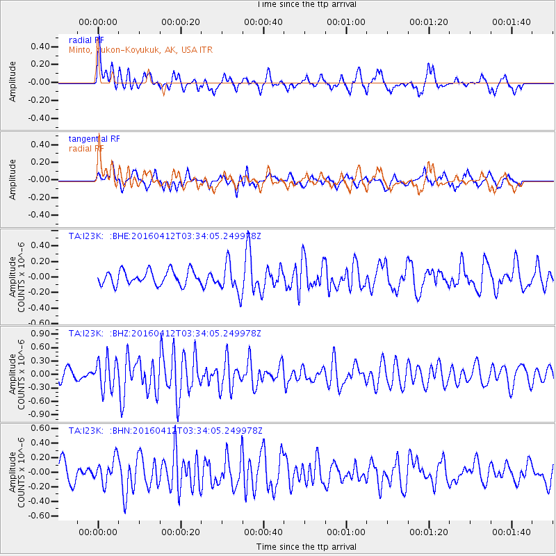
I23K Minto, Yukon-Koyukuk, AK, USA - Earthquake Result Viewer
*The percent match for this event was below the threshold and hence no stack was calculated.
| Earthquake location: |
Central East Pacific Rise |
| Earthquake latitude/longitude: |
-3.8/-103.9 |
| Earthquake time(UTC): |
2016/04/12 (103) 03:22:47 GMT |
| Earthquake Depth: |
10 km |
| Earthquake Magnitude: |
5.8 Mwb |
| Earthquake Catalog/Contributor: |
NEIC PDE/us |
|
| Network: |
TA USArray Transportable Network (new EarthScope stations) |
| Station: |
I23K Minto, Yukon-Koyukuk, AK, USA |
| Lat/Lon: |
65.15 N/149.36 W |
| Elevation: |
149 m |
|
| Distance: |
76.3 deg |
| Az: |
341.949 deg |
| Baz: |
132.975 deg |
| Ray Param: |
$rayparam |
*The percent match for this event was below the threshold and hence was not used in the summary stack. |
|
| Radial Match: |
64.01054 % |
| Radial Bump: |
400 |
| Transverse Match: |
59.048122 % |
| Transverse Bump: |
400 |
| SOD ConfigId: |
7422571 |
| Insert Time: |
2019-04-22 05:20:20.996 +0000 |
| GWidth: |
2.5 |
| Max Bumps: |
400 |
| Tol: |
0.001 |
|
Signal To Noise
| Channel | StoN | STA | LTA |
| TA:I23K: :BHZ:20160412T03:34:05.249978Z | 3.5550005 | 3.3931244E-7 | 9.5446524E-8 |
| TA:I23K: :BHN:20160412T03:34:05.249978Z | 1.2912756 | 1.7191967E-7 | 1.3313941E-7 |
| TA:I23K: :BHE:20160412T03:34:05.249978Z | 2.211885 | 1.9743943E-7 | 8.9262976E-8 |
| Arrivals |
| Ps | |
| PpPs | |
| PsPs/PpSs | |


