You are here: Home > Network List > TA - USArray Transportable Network (new EarthScope stations) Stations List
> Station J26L Joseph Creek, AK, USA > Earthquake Result Viewer
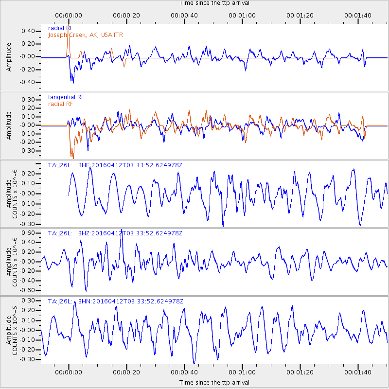
J26L Joseph Creek, AK, USA - Earthquake Result Viewer
*The percent match for this event was below the threshold and hence no stack was calculated.
| Earthquake location: |
Central East Pacific Rise |
| Earthquake latitude/longitude: |
-3.8/-103.9 |
| Earthquake time(UTC): |
2016/04/12 (103) 03:22:47 GMT |
| Earthquake Depth: |
10 km |
| Earthquake Magnitude: |
5.8 Mwb |
| Earthquake Catalog/Contributor: |
NEIC PDE/us |
|
| Network: |
TA USArray Transportable Network (new EarthScope stations) |
| Station: |
J26L Joseph Creek, AK, USA |
| Lat/Lon: |
64.50 N/143.56 W |
| Elevation: |
1144 m |
|
| Distance: |
74.1 deg |
| Az: |
343.318 deg |
| Baz: |
138.566 deg |
| Ray Param: |
$rayparam |
*The percent match for this event was below the threshold and hence was not used in the summary stack. |
|
| Radial Match: |
64.55349 % |
| Radial Bump: |
400 |
| Transverse Match: |
59.082493 % |
| Transverse Bump: |
400 |
| SOD ConfigId: |
7422571 |
| Insert Time: |
2019-04-22 05:20:24.221 +0000 |
| GWidth: |
2.5 |
| Max Bumps: |
400 |
| Tol: |
0.001 |
|
Signal To Noise
| Channel | StoN | STA | LTA |
| TA:J26L: :BHZ:20160412T03:33:52.624978Z | 3.6950388 | 2.6383907E-7 | 7.14036E-8 |
| TA:J26L: :BHN:20160412T03:33:52.624978Z | 1.1663797 | 1.3519903E-7 | 1.15913394E-7 |
| TA:J26L: :BHE:20160412T03:33:52.624978Z | 0.6820489 | 8.775215E-8 | 1.2865961E-7 |
| Arrivals |
| Ps | |
| PpPs | |
| PsPs/PpSs | |


