You are here: Home > Network List > TA - USArray Transportable Network (new EarthScope stations) Stations List
> Station N23A Red Feather Lakes, CO, USA > Earthquake Result Viewer
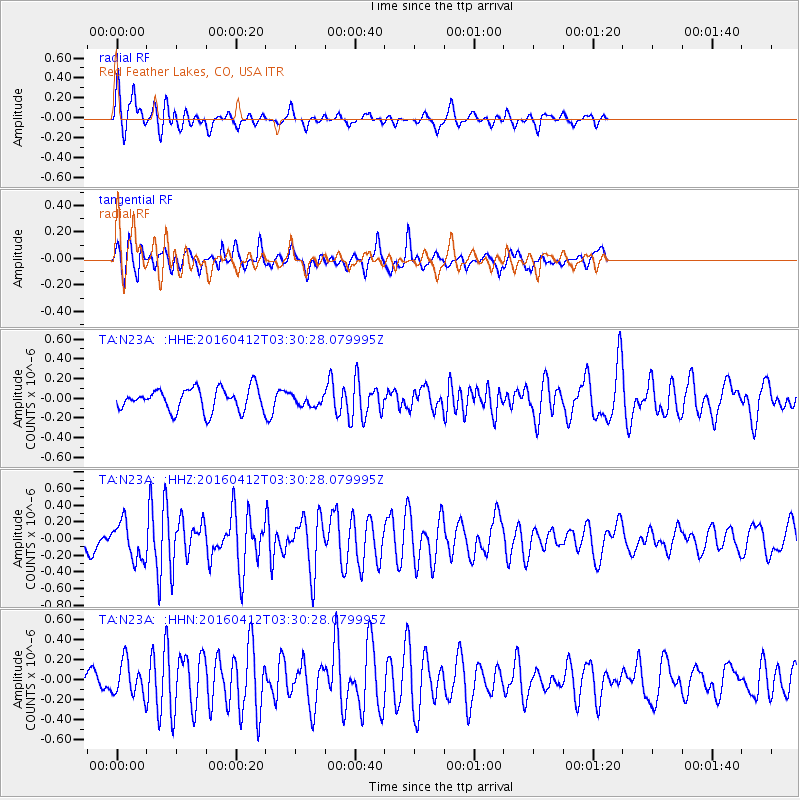
N23A Red Feather Lakes, CO, USA - Earthquake Result Viewer
*The percent match for this event was below the threshold and hence no stack was calculated.
| Earthquake location: |
Central East Pacific Rise |
| Earthquake latitude/longitude: |
-3.8/-103.9 |
| Earthquake time(UTC): |
2016/04/12 (103) 03:22:47 GMT |
| Earthquake Depth: |
10 km |
| Earthquake Magnitude: |
5.8 Mwb |
| Earthquake Catalog/Contributor: |
NEIC PDE/us |
|
| Network: |
TA USArray Transportable Network (new EarthScope stations) |
| Station: |
N23A Red Feather Lakes, CO, USA |
| Lat/Lon: |
40.89 N/105.94 W |
| Elevation: |
2458 m |
|
| Distance: |
44.5 deg |
| Az: |
357.828 deg |
| Baz: |
177.14 deg |
| Ray Param: |
$rayparam |
*The percent match for this event was below the threshold and hence was not used in the summary stack. |
|
| Radial Match: |
68.14021 % |
| Radial Bump: |
390 |
| Transverse Match: |
59.238617 % |
| Transverse Bump: |
350 |
| SOD ConfigId: |
7422571 |
| Insert Time: |
2019-04-22 05:20:33.155 +0000 |
| GWidth: |
2.5 |
| Max Bumps: |
400 |
| Tol: |
0.001 |
|
Signal To Noise
| Channel | StoN | STA | LTA |
| TA:N23A: :HHZ:20160412T03:30:28.079995Z | 2.503566 | 2.2572738E-7 | 9.016234E-8 |
| TA:N23A: :HHN:20160412T03:30:28.079995Z | 1.0771533 | 1.6810931E-7 | 1.5606814E-7 |
| TA:N23A: :HHE:20160412T03:30:28.079995Z | 0.5100246 | 5.7693015E-8 | 1.13118105E-7 |
| Arrivals |
| Ps | |
| PpPs | |
| PsPs/PpSs | |


