You are here: Home > Network List > UU - University of Utah Regional Network Stations List
> Station FORU South Mineral Mountains, UT, USA > Earthquake Result Viewer
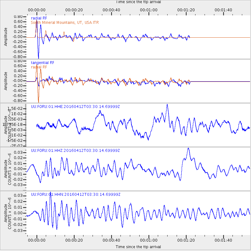
FORU South Mineral Mountains, UT, USA - Earthquake Result Viewer
*The percent match for this event was below the threshold and hence no stack was calculated.
| Earthquake location: |
Central East Pacific Rise |
| Earthquake latitude/longitude: |
-3.8/-103.9 |
| Earthquake time(UTC): |
2016/04/12 (103) 03:22:47 GMT |
| Earthquake Depth: |
10 km |
| Earthquake Magnitude: |
5.8 Mwb |
| Earthquake Catalog/Contributor: |
NEIC PDE/us |
|
| Network: |
UU University of Utah Regional Network |
| Station: |
FORU South Mineral Mountains, UT, USA |
| Lat/Lon: |
38.46 N/112.86 W |
| Elevation: |
1840 m |
|
| Distance: |
42.8 deg |
| Az: |
349.675 deg |
| Baz: |
166.832 deg |
| Ray Param: |
$rayparam |
*The percent match for this event was below the threshold and hence was not used in the summary stack. |
|
| Radial Match: |
82.03589 % |
| Radial Bump: |
400 |
| Transverse Match: |
43.093845 % |
| Transverse Bump: |
400 |
| SOD ConfigId: |
7422571 |
| Insert Time: |
2019-04-22 05:20:56.117 +0000 |
| GWidth: |
2.5 |
| Max Bumps: |
400 |
| Tol: |
0.001 |
|
Signal To Noise
| Channel | StoN | STA | LTA |
| UU:FORU:01:HHZ:20160412T03:30:14.69999Z | 4.348811 | 1.3561645E-8 | 3.118472E-9 |
| UU:FORU:01:HHN:20160412T03:30:14.69999Z | 2.007752 | 6.740668E-9 | 3.3573209E-9 |
| UU:FORU:01:HHE:20160412T03:30:14.69999Z | 2.7282026 | 8.21596E-9 | 3.0114922E-9 |
| Arrivals |
| Ps | |
| PpPs | |
| PsPs/PpSs | |


