You are here: Home > Network List > US - United States National Seismic Network Stations List
> Station WMOK Wichita Mountains, Oklahoma, USA > Earthquake Result Viewer
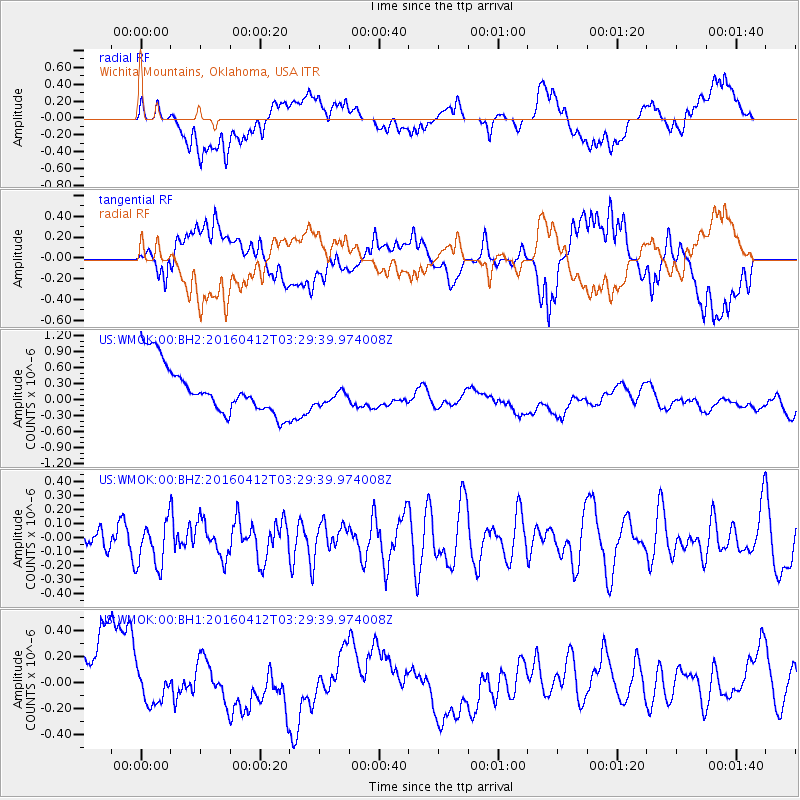
WMOK Wichita Mountains, Oklahoma, USA - Earthquake Result Viewer
*The percent match for this event was below the threshold and hence no stack was calculated.
| Earthquake location: |
Central East Pacific Rise |
| Earthquake latitude/longitude: |
-3.8/-103.9 |
| Earthquake time(UTC): |
2016/04/12 (103) 03:22:47 GMT |
| Earthquake Depth: |
10 km |
| Earthquake Magnitude: |
5.8 Mwb |
| Earthquake Catalog/Contributor: |
NEIC PDE/us |
|
| Network: |
US United States National Seismic Network |
| Station: |
WMOK Wichita Mountains, Oklahoma, USA |
| Lat/Lon: |
34.74 N/98.78 W |
| Elevation: |
486 m |
|
| Distance: |
38.6 deg |
| Az: |
6.813 deg |
| Baz: |
188.265 deg |
| Ray Param: |
$rayparam |
*The percent match for this event was below the threshold and hence was not used in the summary stack. |
|
| Radial Match: |
31.393103 % |
| Radial Bump: |
400 |
| Transverse Match: |
34.23096 % |
| Transverse Bump: |
400 |
| SOD ConfigId: |
7422571 |
| Insert Time: |
2019-04-22 05:21:19.016 +0000 |
| GWidth: |
2.5 |
| Max Bumps: |
400 |
| Tol: |
0.001 |
|
Signal To Noise
| Channel | StoN | STA | LTA |
| US:WMOK:00:BHZ:20160412T03:29:39.974008Z | 1.8988043 | 1.6227072E-7 | 8.5459426E-8 |
| US:WMOK:00:BH1:20160412T03:29:39.974008Z | 0.33683753 | 1.968512E-7 | 5.844099E-7 |
| US:WMOK:00:BH2:20160412T03:29:39.974008Z | 0.3880921 | 1.7742002E-7 | 4.571596E-7 |
| Arrivals |
| Ps | |
| PpPs | |
| PsPs/PpSs | |


