You are here: Home > Network List > UW - Pacific Northwest Regional Seismic Network Stations List
> Station MRBL Marblemount, WA, USA > Earthquake Result Viewer
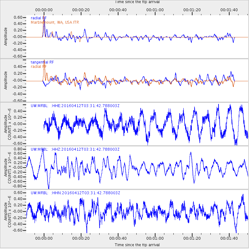
MRBL Marblemount, WA, USA - Earthquake Result Viewer
*The percent match for this event was below the threshold and hence no stack was calculated.
| Earthquake location: |
Central East Pacific Rise |
| Earthquake latitude/longitude: |
-3.8/-103.9 |
| Earthquake time(UTC): |
2016/04/12 (103) 03:22:47 GMT |
| Earthquake Depth: |
10 km |
| Earthquake Magnitude: |
5.8 Mwb |
| Earthquake Catalog/Contributor: |
NEIC PDE/us |
|
| Network: |
UW Pacific Northwest Regional Seismic Network |
| Station: |
MRBL Marblemount, WA, USA |
| Lat/Lon: |
48.52 N/121.48 W |
| Elevation: |
75 m |
|
| Distance: |
54.3 deg |
| Az: |
345.703 deg |
| Baz: |
158.246 deg |
| Ray Param: |
$rayparam |
*The percent match for this event was below the threshold and hence was not used in the summary stack. |
|
| Radial Match: |
78.416466 % |
| Radial Bump: |
400 |
| Transverse Match: |
68.65257 % |
| Transverse Bump: |
400 |
| SOD ConfigId: |
7422571 |
| Insert Time: |
2019-04-22 05:21:24.792 +0000 |
| GWidth: |
2.5 |
| Max Bumps: |
400 |
| Tol: |
0.001 |
|
Signal To Noise
| Channel | StoN | STA | LTA |
| UW:MRBL: :HHZ:20160412T03:31:42.788003Z | 2.7272277 | 4.6949992E-7 | 1.7215282E-7 |
| UW:MRBL: :HHN:20160412T03:31:42.788003Z | 0.6878325 | 1.3385247E-7 | 1.9460039E-7 |
| UW:MRBL: :HHE:20160412T03:31:42.788003Z | 1.7173191 | 2.5729273E-7 | 1.4982231E-7 |
| Arrivals |
| Ps | |
| PpPs | |
| PsPs/PpSs | |


