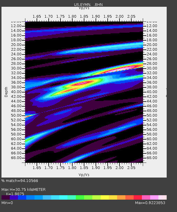
EYMN Ely, Minnesota, USA - Earthquake Result Viewer

Earthquake location: Near Coast Of Jalisco, Mexico
Earthquake latitude/longitude: 18.8/-104.4
Earthquake time(UTC): 2001/05/20 (140) 04:21:43 GMT
Earthquake Depth: 33 km
Earthquake Magnitude: 5.5 MB, 6.0 MS, 6.5 MD, 6.3 MW
Earthquake Catalog/Contributor: WHDF/NEIC
Network: US United States National Seismic Network
Station: EYMN Ely, Minnesota, USA
Lat/Lon: 47.95 N/91.50 W
Elevation: 475 m
Distance: 30.9 deg
Az: 17.055 deg
Baz: 204.407 deg
Ray Param: 0.07917634
Estimated Moho Depth: 30.75 km
Estimated Crust Vp/Vs: 1.99
Assumed Crust Vp: 6.467 km/s
Estimated Crust Vs: 3.254 km/s
Estimated Crust Poisson's Ratio: 0.33
Radial Match: 94.10566 %
Radial Bump: 227
Transverse Match: 77.04307 %
Transverse Bump: 400
SOD ConfigId: 110165
Insert Time: 2010-03-05 01:14:55.932 +0000
GWidth: 2.5
Max Bumps: 400
Tol: 0.001

Signal To Noise

ChannelStoNSTALTA
US:EYMN: :BHN:20010520T04:27:27.175011Z5.2212374.343056E-78.3180595E-8
US:EYMN: :BHE:20010520T04:27:27.175011Z3.85126521.6696065E-74.335216E-8
US:EYMN: :BHZ:20010520T04:27:27.175011Z6.8237416.465778E-79.475415E-8
Arrivals
Ps5.0 SECOND
PpPs13 SECOND
PsPs/PpSs18 SECOND