You are here: Home > Network List > AK - Alaska Regional Network Stations List
> Station COLD Coldfoot Broadband > Earthquake Result Viewer
COLD Coldfoot Broadband - Earthquake Result Viewer
| Earthquake location: |
Myanmar-India Border Region |
| Earthquake latitude/longitude: |
23.1/94.9 |
| Earthquake time(UTC): |
2016/04/13 (104) 13:55:17 GMT |
| Earthquake Depth: |
135 km |
| Earthquake Magnitude: |
6.9 MWB |
| Earthquake Catalog/Contributor: |
NEIC PDE/NEIC COMCAT |
|
| Network: |
AK Alaska Regional Network |
| Station: |
COLD Coldfoot Broadband |
| Lat/Lon: |
67.23 N/150.20 W |
| Elevation: |
377 m |
|
| Distance: |
77.9 deg |
| Az: |
21.166 deg |
| Baz: |
301.37 deg |
| Ray Param: |
0.049656425 |
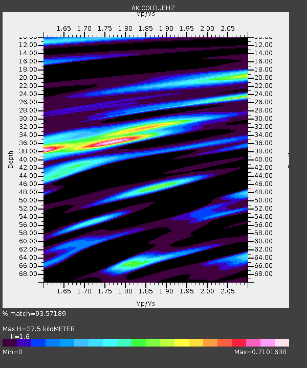
| Estimated Moho Depth: |
37.5 km |
| Estimated Crust Vp/Vs: |
1.60 |
| Assumed Crust Vp: |
6.577 km/s |
| Estimated Crust Vs: |
4.11 km/s |
| Estimated Crust Poisson's Ratio: |
0.18 |
|
| Radial Match: |
93.57189 % |
| Radial Bump: |
393 |
| Transverse Match: |
75.43833 % |
| Transverse Bump: |
400 |
| SOD ConfigId: |
7422571 |
| Insert Time: |
2019-04-22 05:26:03.605 +0000 |
| GWidth: |
2.5 |
| Max Bumps: |
400 |
| Tol: |
0.001 |
|
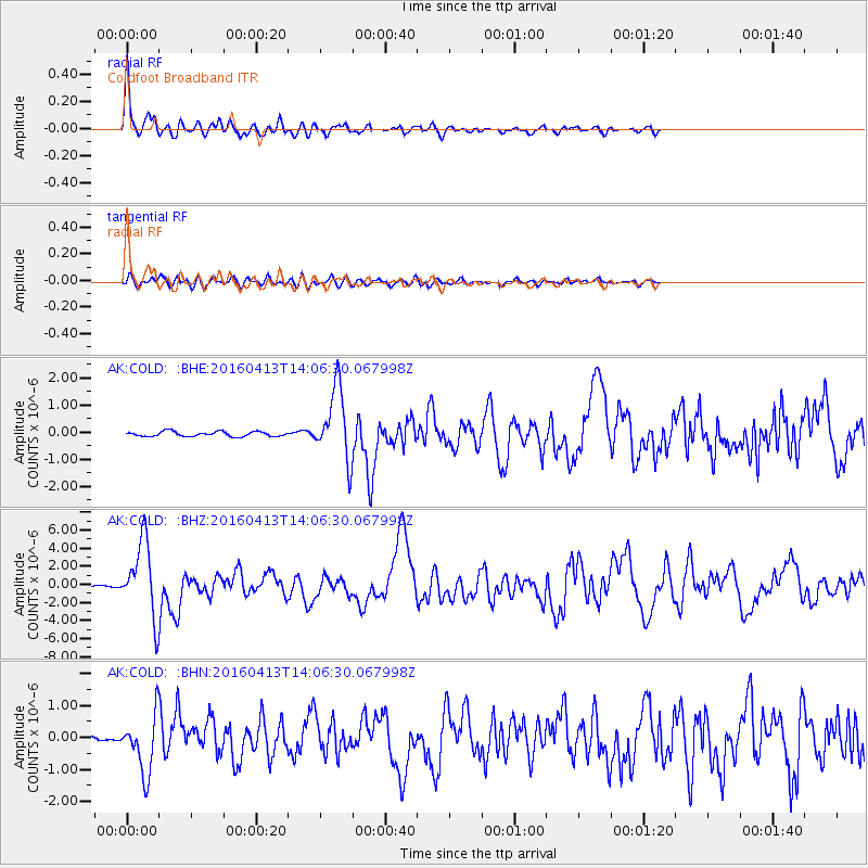
Signal To Noise
| Channel | StoN | STA | LTA |
| AK:COLD: :BHZ:20160413T14:06:30.067998Z | 67.807274 | 4.093447E-6 | 6.036884E-8 |
| AK:COLD: :BHN:20160413T14:06:30.067998Z | 8.287547 | 8.9459076E-7 | 1.07943976E-7 |
| AK:COLD: :BHE:20160413T14:06:30.067998Z | 14.587648 | 1.304508E-6 | 8.942552E-8 |
| Arrivals |
| Ps | 3.5 SECOND |
| PpPs | 14 SECOND |
| PsPs/PpSs | 18 SECOND |


