You are here: Home > Network List > AK - Alaska Regional Network Stations List
> Station GLB Gilahina Butte, AK, USA > Earthquake Result Viewer
GLB Gilahina Butte, AK, USA - Earthquake Result Viewer
| Earthquake location: |
Myanmar-India Border Region |
| Earthquake latitude/longitude: |
23.1/94.9 |
| Earthquake time(UTC): |
2016/04/13 (104) 13:55:17 GMT |
| Earthquake Depth: |
135 km |
| Earthquake Magnitude: |
6.9 MWB |
| Earthquake Catalog/Contributor: |
NEIC PDE/NEIC COMCAT |
|
| Network: |
AK Alaska Regional Network |
| Station: |
GLB Gilahina Butte, AK, USA |
| Lat/Lon: |
61.44 N/143.81 W |
| Elevation: |
855 m |
|
| Distance: |
83.5 deg |
| Az: |
24.411 deg |
| Baz: |
307.653 deg |
| Ray Param: |
0.0458202 |
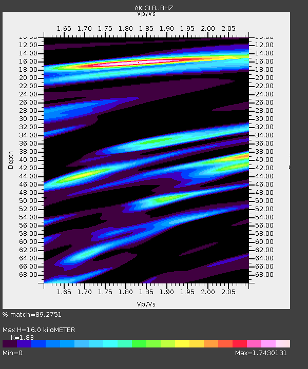
| Estimated Moho Depth: |
16.0 km |
| Estimated Crust Vp/Vs: |
1.83 |
| Assumed Crust Vp: |
6.566 km/s |
| Estimated Crust Vs: |
3.588 km/s |
| Estimated Crust Poisson's Ratio: |
0.29 |
|
| Radial Match: |
89.2751 % |
| Radial Bump: |
400 |
| Transverse Match: |
78.02307 % |
| Transverse Bump: |
400 |
| SOD ConfigId: |
7422571 |
| Insert Time: |
2019-04-22 05:26:15.096 +0000 |
| GWidth: |
2.5 |
| Max Bumps: |
400 |
| Tol: |
0.001 |
|

Signal To Noise
| Channel | StoN | STA | LTA |
| AK:GLB: :BHZ:20160413T14:06:59.607976Z | 39.15405 | 4.762885E-6 | 1.2164476E-7 |
| AK:GLB: :BHN:20160413T14:06:59.607976Z | 4.9307976 | 1.2184929E-6 | 2.4711883E-7 |
| AK:GLB: :BHE:20160413T14:06:59.607976Z | 11.045195 | 1.5761477E-6 | 1.4269986E-7 |
| Arrivals |
| Ps | 2.1 SECOND |
| PpPs | 6.7 SECOND |
| PsPs/PpSs | 8.8 SECOND |


