You are here: Home > Network List > AK - Alaska Regional Network Stations List
> Station LOGN Logan Glacier, AK, USA > Earthquake Result Viewer
LOGN Logan Glacier, AK, USA - Earthquake Result Viewer
| Earthquake location: |
Myanmar-India Border Region |
| Earthquake latitude/longitude: |
23.1/94.9 |
| Earthquake time(UTC): |
2016/04/13 (104) 13:55:17 GMT |
| Earthquake Depth: |
135 km |
| Earthquake Magnitude: |
6.9 MWB |
| Earthquake Catalog/Contributor: |
NEIC PDE/NEIC COMCAT |
|
| Network: |
AK Alaska Regional Network |
| Station: |
LOGN Logan Glacier, AK, USA |
| Lat/Lon: |
60.82 N/141.00 W |
| Elevation: |
1665 m |
|
| Distance: |
85.0 deg |
| Az: |
24.037 deg |
| Baz: |
310.071 deg |
| Ray Param: |
0.04479662 |
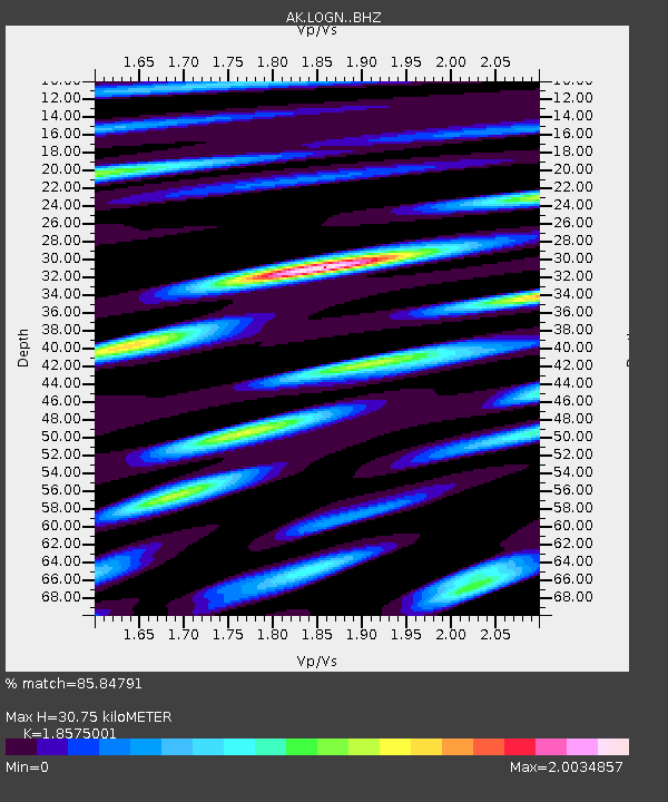
| Estimated Moho Depth: |
30.75 km |
| Estimated Crust Vp/Vs: |
1.86 |
| Assumed Crust Vp: |
6.566 km/s |
| Estimated Crust Vs: |
3.535 km/s |
| Estimated Crust Poisson's Ratio: |
0.30 |
|
| Radial Match: |
85.84791 % |
| Radial Bump: |
400 |
| Transverse Match: |
79.35359 % |
| Transverse Bump: |
400 |
| SOD ConfigId: |
7422571 |
| Insert Time: |
2019-04-22 05:26:28.963 +0000 |
| GWidth: |
2.5 |
| Max Bumps: |
400 |
| Tol: |
0.001 |
|

Signal To Noise
| Channel | StoN | STA | LTA |
| AK:LOGN: :BHZ:20160413T14:07:06.888005Z | 13.665735 | 4.6254545E-6 | 3.3847095E-7 |
| AK:LOGN: :BHN:20160413T14:07:06.888005Z | 4.127137 | 1.1266839E-6 | 2.7299404E-7 |
| AK:LOGN: :BHE:20160413T14:07:06.888005Z | 3.636002 | 1.1874374E-6 | 3.2657775E-7 |
| Arrivals |
| Ps | 4.1 SECOND |
| PpPs | 13 SECOND |
| PsPs/PpSs | 17 SECOND |


