You are here: Home > Network List > AK - Alaska Regional Network Stations List
> Station TNA Tin City Broadband > Earthquake Result Viewer
TNA Tin City Broadband - Earthquake Result Viewer
| Earthquake location: |
Myanmar-India Border Region |
| Earthquake latitude/longitude: |
23.1/94.9 |
| Earthquake time(UTC): |
2016/04/13 (104) 13:55:17 GMT |
| Earthquake Depth: |
135 km |
| Earthquake Magnitude: |
6.9 MWB |
| Earthquake Catalog/Contributor: |
NEIC PDE/NEIC COMCAT |
|
| Network: |
AK Alaska Regional Network |
| Station: |
TNA Tin City Broadband |
| Lat/Lon: |
65.56 N/167.92 W |
| Elevation: |
74 m |
|
| Distance: |
72.1 deg |
| Az: |
25.708 deg |
| Baz: |
286.301 deg |
| Ray Param: |
0.053540528 |
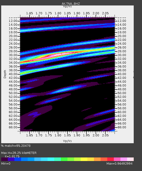
| Estimated Moho Depth: |
29.25 km |
| Estimated Crust Vp/Vs: |
1.82 |
| Assumed Crust Vp: |
6.307 km/s |
| Estimated Crust Vs: |
3.47 km/s |
| Estimated Crust Poisson's Ratio: |
0.28 |
|
| Radial Match: |
95.20478 % |
| Radial Bump: |
350 |
| Transverse Match: |
78.567566 % |
| Transverse Bump: |
400 |
| SOD ConfigId: |
7422571 |
| Insert Time: |
2019-04-22 05:26:53.535 +0000 |
| GWidth: |
2.5 |
| Max Bumps: |
400 |
| Tol: |
0.001 |
|

Signal To Noise
| Channel | StoN | STA | LTA |
| AK:TNA: :BHZ:20160413T14:05:56.687993Z | 28.534351 | 3.110482E-6 | 1.0900833E-7 |
| AK:TNA: :BHN:20160413T14:05:56.687993Z | 3.7111788 | 3.4951054E-7 | 9.417777E-8 |
| AK:TNA: :BHE:20160413T14:05:56.687993Z | 14.817917 | 1.1902276E-6 | 8.032355E-8 |
| Arrivals |
| Ps | 3.9 SECOND |
| PpPs | 13 SECOND |
| PsPs/PpSs | 17 SECOND |


