You are here: Home > Network List > AU - Australian Seismological Centre Stations List
> Station BBOO Buckleboo, South Australia > Earthquake Result Viewer
BBOO Buckleboo, South Australia - Earthquake Result Viewer
| Earthquake location: |
Myanmar-India Border Region |
| Earthquake latitude/longitude: |
23.1/94.9 |
| Earthquake time(UTC): |
2016/04/13 (104) 13:55:17 GMT |
| Earthquake Depth: |
135 km |
| Earthquake Magnitude: |
6.9 MWB |
| Earthquake Catalog/Contributor: |
NEIC PDE/NEIC COMCAT |
|
| Network: |
AU Australian Seismological Centre |
| Station: |
BBOO Buckleboo, South Australia |
| Lat/Lon: |
32.81 S/136.06 E |
| Elevation: |
321 m |
|
| Distance: |
68.1 deg |
| Az: |
143.32 deg |
| Baz: |
319.233 deg |
| Ray Param: |
0.056162413 |
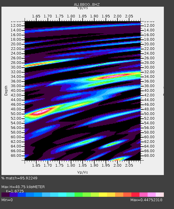
| Estimated Moho Depth: |
48.75 km |
| Estimated Crust Vp/Vs: |
1.67 |
| Assumed Crust Vp: |
6.65 km/s |
| Estimated Crust Vs: |
3.976 km/s |
| Estimated Crust Poisson's Ratio: |
0.22 |
|
| Radial Match: |
95.92249 % |
| Radial Bump: |
400 |
| Transverse Match: |
79.67064 % |
| Transverse Bump: |
400 |
| SOD ConfigId: |
7422571 |
| Insert Time: |
2019-04-22 05:27:08.925 +0000 |
| GWidth: |
2.5 |
| Max Bumps: |
400 |
| Tol: |
0.001 |
|

Signal To Noise
| Channel | StoN | STA | LTA |
| AU:BBOO: :BHZ:20160413T14:05:32.044011Z | 145.6304 | 2.7731101E-5 | 1.9042109E-7 |
| AU:BBOO: :BHN:20160413T14:05:32.044011Z | 55.860485 | 9.310666E-6 | 1.6667715E-7 |
| AU:BBOO: :BHE:20160413T14:05:32.044011Z | 71.415146 | 8.385779E-6 | 1.1742298E-7 |
| Arrivals |
| Ps | 5.2 SECOND |
| PpPs | 19 SECOND |
| PsPs/PpSs | 24 SECOND |


