You are here: Home > Network List > AU - Australian Seismological Centre Stations List
> Station EIDS Eidsvold, Queensland > Earthquake Result Viewer
EIDS Eidsvold, Queensland - Earthquake Result Viewer
| Earthquake location: |
Myanmar-India Border Region |
| Earthquake latitude/longitude: |
23.1/94.9 |
| Earthquake time(UTC): |
2016/04/13 (104) 13:55:17 GMT |
| Earthquake Depth: |
135 km |
| Earthquake Magnitude: |
6.9 MWB |
| Earthquake Catalog/Contributor: |
NEIC PDE/NEIC COMCAT |
|
| Network: |
AU Australian Seismological Centre |
| Station: |
EIDS Eidsvold, Queensland |
| Lat/Lon: |
25.37 S/151.08 E |
| Elevation: |
216 m |
|
| Distance: |
72.7 deg |
| Az: |
128.081 deg |
| Baz: |
306.779 deg |
| Ray Param: |
0.053136494 |
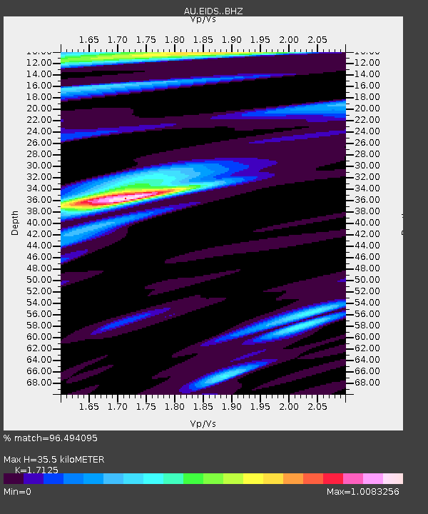
| Estimated Moho Depth: |
35.5 km |
| Estimated Crust Vp/Vs: |
1.71 |
| Assumed Crust Vp: |
6.577 km/s |
| Estimated Crust Vs: |
3.84 km/s |
| Estimated Crust Poisson's Ratio: |
0.24 |
|
| Radial Match: |
96.494095 % |
| Radial Bump: |
397 |
| Transverse Match: |
87.80384 % |
| Transverse Bump: |
400 |
| SOD ConfigId: |
7422571 |
| Insert Time: |
2019-04-22 05:27:14.183 +0000 |
| GWidth: |
2.5 |
| Max Bumps: |
400 |
| Tol: |
0.001 |
|

Signal To Noise
| Channel | StoN | STA | LTA |
| AU:EIDS: :BHZ:20160413T14:06:00.093999Z | 87.47598 | 1.759563E-5 | 2.0114814E-7 |
| AU:EIDS: :BHN:20160413T14:06:00.093999Z | 22.134777 | 3.4984687E-6 | 1.5805304E-7 |
| AU:EIDS: :BHE:20160413T14:06:00.093999Z | 29.687677 | 5.042967E-6 | 1.6986735E-7 |
| Arrivals |
| Ps | 4.0 SECOND |
| PpPs | 14 SECOND |
| PsPs/PpSs | 18 SECOND |


