You are here: Home > Network List > AV - Alaska Volcano Observatory Stations List
> Station IVE Iliamna Volcano East, Cook Inlet, Alaska > Earthquake Result Viewer
IVE Iliamna Volcano East, Cook Inlet, Alaska - Earthquake Result Viewer
| Earthquake location: |
Myanmar-India Border Region |
| Earthquake latitude/longitude: |
23.1/94.9 |
| Earthquake time(UTC): |
2016/04/13 (104) 13:55:17 GMT |
| Earthquake Depth: |
135 km |
| Earthquake Magnitude: |
6.9 MWB |
| Earthquake Catalog/Contributor: |
NEIC PDE/NEIC COMCAT |
|
| Network: |
AV Alaska Volcano Observatory |
| Station: |
IVE Iliamna Volcano East, Cook Inlet, Alaska |
| Lat/Lon: |
60.02 N/153.02 W |
| Elevation: |
1173 m |
|
| Distance: |
80.6 deg |
| Az: |
28.152 deg |
| Baz: |
300.149 deg |
| Ray Param: |
0.047880832 |
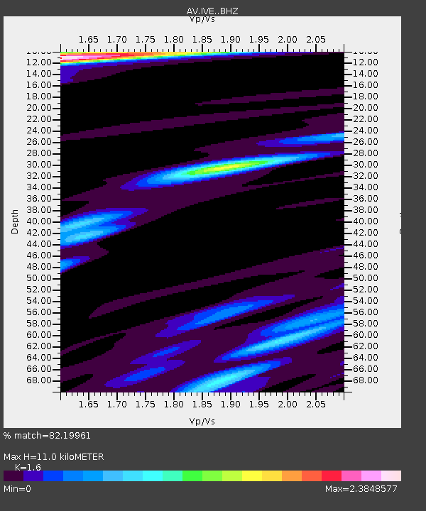
| Estimated Moho Depth: |
11.0 km |
| Estimated Crust Vp/Vs: |
1.60 |
| Assumed Crust Vp: |
6.566 km/s |
| Estimated Crust Vs: |
4.104 km/s |
| Estimated Crust Poisson's Ratio: |
0.18 |
|
| Radial Match: |
82.19961 % |
| Radial Bump: |
400 |
| Transverse Match: |
74.33756 % |
| Transverse Bump: |
400 |
| SOD ConfigId: |
7422571 |
| Insert Time: |
2019-04-22 05:27:38.974 +0000 |
| GWidth: |
2.5 |
| Max Bumps: |
400 |
| Tol: |
0.001 |
|

Signal To Noise
| Channel | StoN | STA | LTA |
| AV:IVE: :BHZ:20160413T14:06:44.250005Z | 9.29117 | 2.8738054E-6 | 3.0930502E-7 |
| AV:IVE: :BHN:20160413T14:06:44.250005Z | 3.097027 | 1.1002563E-6 | 3.5526207E-7 |
| AV:IVE: :BHE:20160413T14:06:44.250005Z | 4.8621626 | 1.1800336E-6 | 2.4269724E-7 |
| Arrivals |
| Ps | 1.0 SECOND |
| PpPs | 4.2 SECOND |
| PsPs/PpSs | 5.3 SECOND |


