You are here: Home > Network List > AV - Alaska Volcano Observatory Stations List
> Station RDWB Redoubt, Jurgen's Hut, Redoubt Alaska > Earthquake Result Viewer
RDWB Redoubt, Jurgen's Hut, Redoubt Alaska - Earthquake Result Viewer
| Earthquake location: |
Myanmar-India Border Region |
| Earthquake latitude/longitude: |
23.1/94.9 |
| Earthquake time(UTC): |
2016/04/13 (104) 13:55:17 GMT |
| Earthquake Depth: |
135 km |
| Earthquake Magnitude: |
6.9 MWB |
| Earthquake Catalog/Contributor: |
NEIC PDE/NEIC COMCAT |
|
| Network: |
AV Alaska Volcano Observatory |
| Station: |
RDWB Redoubt, Jurgen's Hut, Redoubt Alaska |
| Lat/Lon: |
60.49 N/152.84 W |
| Elevation: |
1546 m |
|
| Distance: |
80.4 deg |
| Az: |
27.693 deg |
| Baz: |
300.226 deg |
| Ray Param: |
0.04799139 |
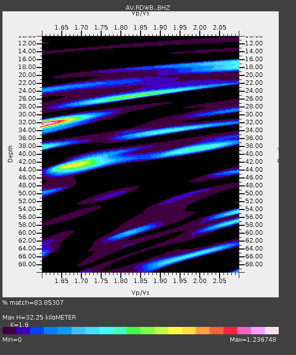
| Estimated Moho Depth: |
32.25 km |
| Estimated Crust Vp/Vs: |
1.60 |
| Assumed Crust Vp: |
6.566 km/s |
| Estimated Crust Vs: |
4.104 km/s |
| Estimated Crust Poisson's Ratio: |
0.18 |
|
| Radial Match: |
83.85307 % |
| Radial Bump: |
400 |
| Transverse Match: |
86.02257 % |
| Transverse Bump: |
400 |
| SOD ConfigId: |
7422571 |
| Insert Time: |
2019-04-22 05:27:44.469 +0000 |
| GWidth: |
2.5 |
| Max Bumps: |
400 |
| Tol: |
0.001 |
|

Signal To Noise
| Channel | StoN | STA | LTA |
| AV:RDWB: :BHZ:20160413T14:06:43.38001Z | 22.554277 | 4.401426E-6 | 1.9514817E-7 |
| AV:RDWB: :BHN:20160413T14:06:43.38001Z | 3.375909 | 7.20532E-7 | 2.1343348E-7 |
| AV:RDWB: :BHE:20160413T14:06:43.38001Z | 6.5562186 | 1.6383996E-6 | 2.4990007E-7 |
| Arrivals |
| Ps | 3.0 SECOND |
| PpPs | 12 SECOND |
| PsPs/PpSs | 15 SECOND |


