You are here: Home > Network List > US - United States National Seismic Network Stations List
> Station EYMN Ely, Minnesota, USA > Earthquake Result Viewer
EYMN Ely, Minnesota, USA - Earthquake Result Viewer

| Earthquake location: |
Kamchatka Peninsula, Russia |
| Earthquake latitude/longitude: |
55.5/160.0 |
| Earthquake time(UTC): |
2003/06/16 (167) 22:08:02 GMT |
| Earthquake Depth: |
175 km |
| Earthquake Magnitude: |
6.3 MB, 6.9 MW, 6.9 MW |
| Earthquake Catalog/Contributor: |
WHDF/NEIC |
|
| Network: |
US United States National Seismic Network |
| Station: |
EYMN Ely, Minnesota, USA |
| Lat/Lon: |
47.95 N/91.50 W |
| Elevation: |
475 m |
|
| Distance: |
60.8 deg |
| Az: |
46.892 deg |
| Baz: |
321.829 deg |
| Ray Param: |
0.060727544 |
| Estimated Moho Depth: |
46.0 km |
| Estimated Crust Vp/Vs: |
1.71 |
| Assumed Crust Vp: |
6.467 km/s |
| Estimated Crust Vs: |
3.793 km/s |
| Estimated Crust Poisson's Ratio: |
0.24 |
|
| Radial Match: |
98.17323 % |
| Radial Bump: |
313 |
| Transverse Match: |
87.3834 % |
| Transverse Bump: |
400 |
| SOD ConfigId: |
110177 |
| Insert Time: |
2010-03-05 01:15:51.609 +0000 |
| GWidth: |
2.5 |
| Max Bumps: |
400 |
| Tol: |
0.001 |
|
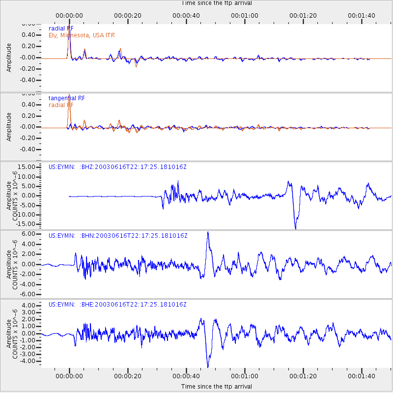
Signal To Noise
| Channel | StoN | STA | LTA |
| US:EYMN: :BHN:20030616T22:17:25.181016Z | 7.1177645 | 8.7811225E-7 | 1.233691E-7 |
| US:EYMN: :BHE:20030616T22:17:25.181016Z | 5.527096 | 5.498568E-7 | 9.948386E-8 |
| US:EYMN: :BHZ:20030616T22:17:25.181016Z | 18.511608 | 2.14371E-6 | 1.15803545E-7 |
| Arrivals |
| Ps | 5.3 SECOND |
| PpPs | 18 SECOND |
| PsPs/PpSs | 24 SECOND |


