You are here: Home > Network List > CB - China National Seismic Network Stations List
> Station SNY Shenyang,Liaoning Province > Earthquake Result Viewer
SNY Shenyang,Liaoning Province - Earthquake Result Viewer
| Earthquake location: |
Myanmar-India Border Region |
| Earthquake latitude/longitude: |
23.1/94.9 |
| Earthquake time(UTC): |
2016/04/13 (104) 13:55:17 GMT |
| Earthquake Depth: |
135 km |
| Earthquake Magnitude: |
6.9 MWB |
| Earthquake Catalog/Contributor: |
NEIC PDE/NEIC COMCAT |
|
| Network: |
CB China National Seismic Network |
| Station: |
SNY Shenyang,Liaoning Province |
| Lat/Lon: |
41.83 N/123.58 E |
| Elevation: |
54 m |
|
| Distance: |
30.3 deg |
| Az: |
45.255 deg |
| Baz: |
241.024 deg |
| Ray Param: |
0.07912478 |
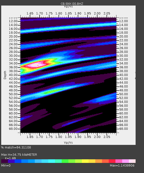
| Estimated Moho Depth: |
34.75 km |
| Estimated Crust Vp/Vs: |
1.69 |
| Assumed Crust Vp: |
6.464 km/s |
| Estimated Crust Vs: |
3.825 km/s |
| Estimated Crust Poisson's Ratio: |
0.23 |
|
| Radial Match: |
94.31108 % |
| Radial Bump: |
252 |
| Transverse Match: |
75.77243 % |
| Transverse Bump: |
400 |
| SOD ConfigId: |
7422571 |
| Insert Time: |
2019-04-22 05:27:54.415 +0000 |
| GWidth: |
2.5 |
| Max Bumps: |
400 |
| Tol: |
0.001 |
|

Signal To Noise
| Channel | StoN | STA | LTA |
| CB:SNY:00:BHZ:20160413T14:00:46.729985Z | 42.18863 | 4.660769E-6 | 1.10474524E-7 |
| CB:SNY:00:BHN:20160413T14:00:46.729985Z | 13.990835 | 1.6259644E-6 | 1.1621639E-7 |
| CB:SNY:00:BHE:20160413T14:00:46.729985Z | 22.849945 | 2.9087298E-6 | 1.2729701E-7 |
| Arrivals |
| Ps | 4.0 SECOND |
| PpPs | 13 SECOND |
| PsPs/PpSs | 17 SECOND |


