You are here: Home > Network List > CZ - Czech Regional Seismic Network Stations List
> Station DPC Dobruska, Czech Republic > Earthquake Result Viewer
DPC Dobruska, Czech Republic - Earthquake Result Viewer
| Earthquake location: |
Myanmar-India Border Region |
| Earthquake latitude/longitude: |
23.1/94.9 |
| Earthquake time(UTC): |
2016/04/13 (104) 13:55:17 GMT |
| Earthquake Depth: |
135 km |
| Earthquake Magnitude: |
6.9 MWB |
| Earthquake Catalog/Contributor: |
NEIC PDE/NEIC COMCAT |
|
| Network: |
CZ Czech Regional Seismic Network |
| Station: |
DPC Dobruska, Czech Republic |
| Lat/Lon: |
50.36 N/16.41 E |
| Elevation: |
760 m |
|
| Distance: |
65.3 deg |
| Az: |
316.309 deg |
| Baz: |
83.101 deg |
| Ray Param: |
0.057975486 |
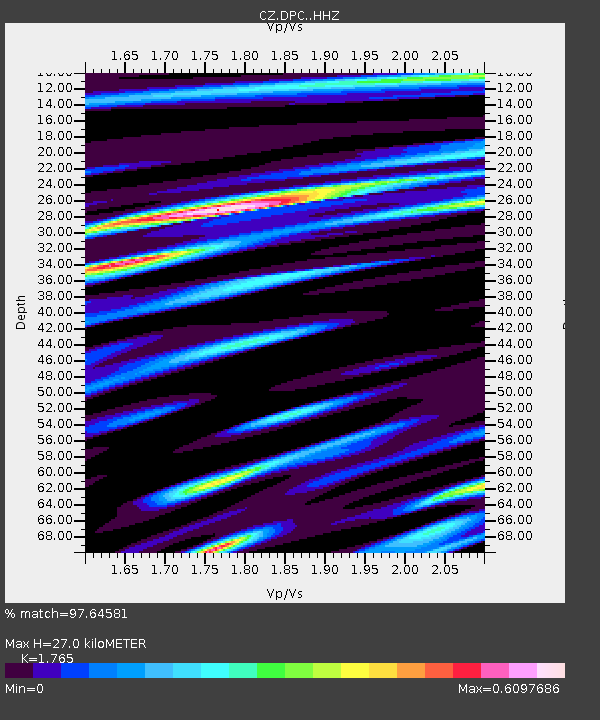
| Estimated Moho Depth: |
27.0 km |
| Estimated Crust Vp/Vs: |
1.76 |
| Assumed Crust Vp: |
6.194 km/s |
| Estimated Crust Vs: |
3.509 km/s |
| Estimated Crust Poisson's Ratio: |
0.26 |
|
| Radial Match: |
97.64581 % |
| Radial Bump: |
251 |
| Transverse Match: |
87.091675 % |
| Transverse Bump: |
400 |
| SOD ConfigId: |
7422571 |
| Insert Time: |
2019-04-22 05:28:23.076 +0000 |
| GWidth: |
2.5 |
| Max Bumps: |
400 |
| Tol: |
0.001 |
|
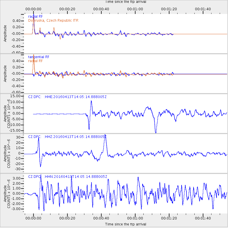
Signal To Noise
| Channel | StoN | STA | LTA |
| CZ:DPC: :HHZ:20160413T14:05:14.888005Z | 176.1545 | 1.2604656E-5 | 7.155456E-8 |
| CZ:DPC: :HHN:20160413T14:05:14.888005Z | 15.7529335 | 1.5196426E-6 | 9.6467275E-8 |
| CZ:DPC: :HHE:20160413T14:05:14.888005Z | 74.55261 | 5.591006E-6 | 7.4994105E-8 |
| Arrivals |
| Ps | 3.5 SECOND |
| PpPs | 12 SECOND |
| PsPs/PpSs | 15 SECOND |


