You are here: Home > Network List > GB - Great Britain Seismograph Network Stations List
> Station CWF CHARNWOOD FOREST, ENGLAND > Earthquake Result Viewer
CWF CHARNWOOD FOREST, ENGLAND - Earthquake Result Viewer
| Earthquake location: |
Myanmar-India Border Region |
| Earthquake latitude/longitude: |
23.1/94.9 |
| Earthquake time(UTC): |
2016/04/13 (104) 13:55:17 GMT |
| Earthquake Depth: |
135 km |
| Earthquake Magnitude: |
6.9 MWB |
| Earthquake Catalog/Contributor: |
NEIC PDE/NEIC COMCAT |
|
| Network: |
GB Great Britain Seismograph Network |
| Station: |
CWF CHARNWOOD FOREST, ENGLAND |
| Lat/Lon: |
52.74 N/1.31 W |
| Elevation: |
203 m |
|
| Distance: |
75.5 deg |
| Az: |
321.375 deg |
| Baz: |
70.92 deg |
| Ray Param: |
0.051262 |
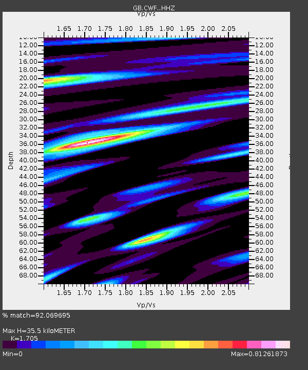
| Estimated Moho Depth: |
35.5 km |
| Estimated Crust Vp/Vs: |
1.71 |
| Assumed Crust Vp: |
6.276 km/s |
| Estimated Crust Vs: |
3.681 km/s |
| Estimated Crust Poisson's Ratio: |
0.24 |
|
| Radial Match: |
92.069695 % |
| Radial Bump: |
400 |
| Transverse Match: |
83.52377 % |
| Transverse Bump: |
400 |
| SOD ConfigId: |
7422571 |
| Insert Time: |
2019-04-22 05:28:43.964 +0000 |
| GWidth: |
2.5 |
| Max Bumps: |
400 |
| Tol: |
0.001 |
|

Signal To Noise
| Channel | StoN | STA | LTA |
| GB:CWF: :HHZ:20160413T14:06:16.469976Z | 26.718128 | 1.105983E-5 | 4.139448E-7 |
| GB:CWF: :HHN:20160413T14:06:16.469976Z | 4.149256 | 2.0178823E-6 | 4.8632387E-7 |
| GB:CWF: :HHE:20160413T14:06:16.469976Z | 15.374283 | 3.9888105E-6 | 2.5944695E-7 |
| Arrivals |
| Ps | 4.1 SECOND |
| PpPs | 15 SECOND |
| PsPs/PpSs | 19 SECOND |


