You are here: Home > Network List > GB - Great Britain Seismograph Network Stations List
> Station CCA1 CARNMENELLIS, ENGLAND > Earthquake Result Viewer
CCA1 CARNMENELLIS, ENGLAND - Earthquake Result Viewer
| Earthquake location: |
Myanmar-India Border Region |
| Earthquake latitude/longitude: |
23.1/94.9 |
| Earthquake time(UTC): |
2016/04/13 (104) 13:55:17 GMT |
| Earthquake Depth: |
135 km |
| Earthquake Magnitude: |
6.9 MWB |
| Earthquake Catalog/Contributor: |
NEIC PDE/NEIC COMCAT |
|
| Network: |
GB Great Britain Seismograph Network |
| Station: |
CCA1 CARNMENELLIS, ENGLAND |
| Lat/Lon: |
50.19 N/5.23 W |
| Elevation: |
209 m |
|
| Distance: |
78.7 deg |
| Az: |
319.818 deg |
| Baz: |
67.514 deg |
| Ray Param: |
0.049113844 |
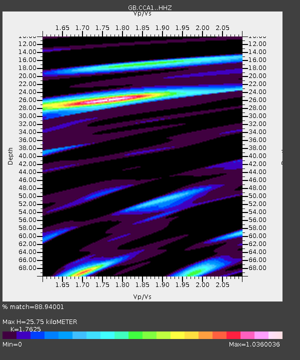
| Estimated Moho Depth: |
25.75 km |
| Estimated Crust Vp/Vs: |
1.76 |
| Assumed Crust Vp: |
6.24 km/s |
| Estimated Crust Vs: |
3.54 km/s |
| Estimated Crust Poisson's Ratio: |
0.26 |
|
| Radial Match: |
88.94001 % |
| Radial Bump: |
317 |
| Transverse Match: |
75.07152 % |
| Transverse Bump: |
400 |
| SOD ConfigId: |
7422571 |
| Insert Time: |
2019-04-22 05:28:43.727 +0000 |
| GWidth: |
2.5 |
| Max Bumps: |
400 |
| Tol: |
0.001 |
|

Signal To Noise
| Channel | StoN | STA | LTA |
| GB:CCA1: :HHZ:20160413T14:06:34.260015Z | 19.716473 | 1.1971176E-5 | 6.071662E-7 |
| GB:CCA1: :HHN:20160413T14:06:34.260015Z | 4.0112753 | 1.908311E-6 | 4.757368E-7 |
| GB:CCA1: :HHE:20160413T14:06:34.260015Z | 13.221528 | 5.124294E-6 | 3.8757202E-7 |
| Arrivals |
| Ps | 3.2 SECOND |
| PpPs | 11 SECOND |
| PsPs/PpSs | 14 SECOND |


