You are here: Home > Network List > US - United States National Seismic Network Stations List
> Station EYMN Ely, Minnesota, USA > Earthquake Result Viewer
EYMN Ely, Minnesota, USA - Earthquake Result Viewer

| Earthquake location: |
Samoa Islands Region |
| Earthquake latitude/longitude: |
-14.8/-175.1 |
| Earthquake time(UTC): |
2004/10/11 (285) 22:03:46 GMT |
| Earthquake Depth: |
10 km |
| Earthquake Magnitude: |
5.4 MB, 5.2 MS, 5.7 MW, 5.7 MW |
| Earthquake Catalog/Contributor: |
WHDF/NEIC |
|
| Network: |
US United States National Seismic Network |
| Station: |
EYMN Ely, Minnesota, USA |
| Lat/Lon: |
47.95 N/91.50 W |
| Elevation: |
475 m |
|
| Distance: |
96.6 deg |
| Az: |
42.267 deg |
| Baz: |
255.37 deg |
| Ray Param: |
0.040458597 |
| Estimated Moho Depth: |
10.0 km |
| Estimated Crust Vp/Vs: |
1.60 |
| Assumed Crust Vp: |
6.467 km/s |
| Estimated Crust Vs: |
4.042 km/s |
| Estimated Crust Poisson's Ratio: |
0.18 |
|
| Radial Match: |
99.72889 % |
| Radial Bump: |
22 |
| Transverse Match: |
99.31215 % |
| Transverse Bump: |
11 |
| SOD ConfigId: |
110165 |
| Insert Time: |
2010-03-05 01:16:14.299 +0000 |
| GWidth: |
2.5 |
| Max Bumps: |
400 |
| Tol: |
0.001 |
|
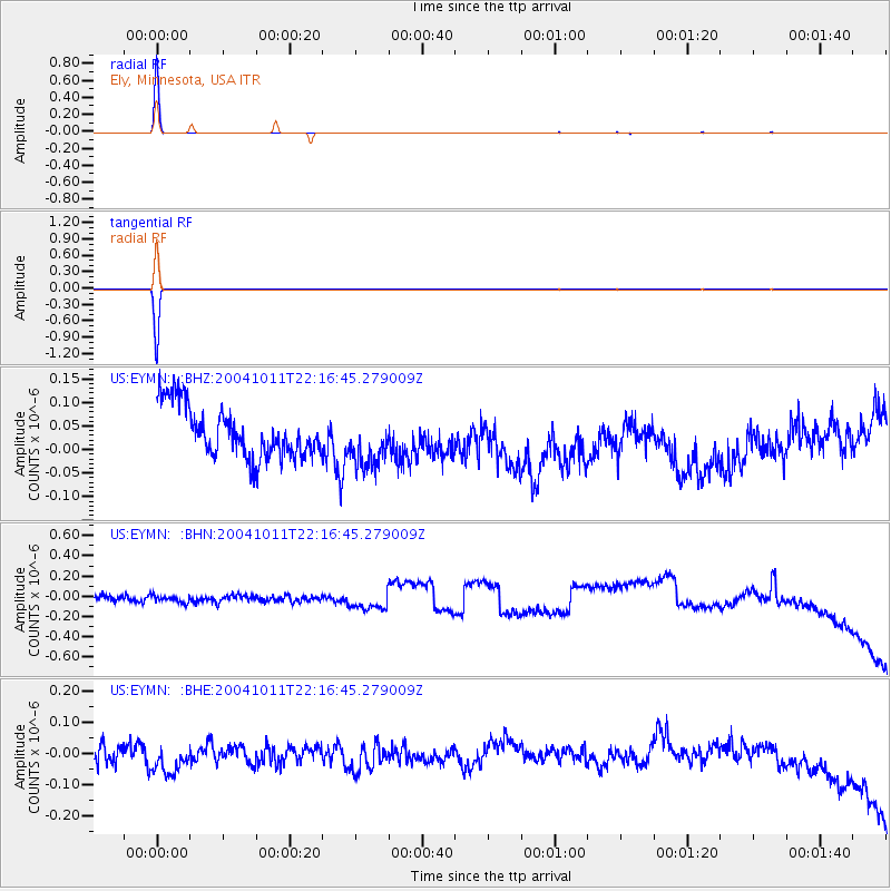
Signal To Noise
| Channel | StoN | STA | LTA |
| US:EYMN: :BHN:20041011T22:16:45.279009Z | 1.0059202 | 6.7319256E-8 | 6.6923064E-8 |
| US:EYMN: :BHE:20041011T22:16:45.279009Z | 1.6255935 | 5.8872295E-8 | 3.6215877E-8 |
| US:EYMN: :BHZ:20041011T22:16:45.279009Z | 1.0038702 | 5.4358857E-8 | 5.4149286E-8 |
| Arrivals |
| Ps | 0.9 SECOND |
| PpPs | 3.9 SECOND |
| PsPs/PpSs | 4.9 SECOND |


