You are here: Home > Network List > GB - Great Britain Seismograph Network Stations List
> Station LBWR LADYBOWER, ENGLAND > Earthquake Result Viewer
LBWR LADYBOWER, ENGLAND - Earthquake Result Viewer
| Earthquake location: |
Myanmar-India Border Region |
| Earthquake latitude/longitude: |
23.1/94.9 |
| Earthquake time(UTC): |
2016/04/13 (104) 13:55:17 GMT |
| Earthquake Depth: |
135 km |
| Earthquake Magnitude: |
6.9 MWB |
| Earthquake Catalog/Contributor: |
NEIC PDE/NEIC COMCAT |
|
| Network: |
GB Great Britain Seismograph Network |
| Station: |
LBWR LADYBOWER, ENGLAND |
| Lat/Lon: |
53.40 N/1.72 W |
| Elevation: |
353 m |
|
| Distance: |
75.6 deg |
| Az: |
322.108 deg |
| Baz: |
70.77 deg |
| Ray Param: |
0.051248766 |
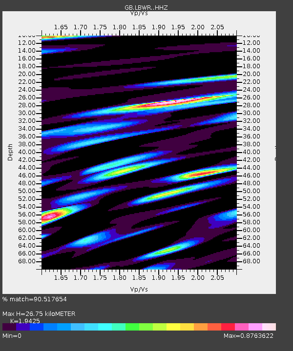
| Estimated Moho Depth: |
26.75 km |
| Estimated Crust Vp/Vs: |
1.94 |
| Assumed Crust Vp: |
6.276 km/s |
| Estimated Crust Vs: |
3.231 km/s |
| Estimated Crust Poisson's Ratio: |
0.32 |
|
| Radial Match: |
90.517654 % |
| Radial Bump: |
369 |
| Transverse Match: |
85.858734 % |
| Transverse Bump: |
400 |
| SOD ConfigId: |
7422571 |
| Insert Time: |
2019-04-22 05:28:57.490 +0000 |
| GWidth: |
2.5 |
| Max Bumps: |
400 |
| Tol: |
0.001 |
|

Signal To Noise
| Channel | StoN | STA | LTA |
| GB:LBWR: :HHZ:20160413T14:06:16.589971Z | 14.813629 | 3.1636493E-5 | 2.1356343E-6 |
| GB:LBWR: :HHN:20160413T14:06:16.589971Z | 9.184341 | 1.0555052E-5 | 1.1492443E-6 |
| GB:LBWR: :HHE:20160413T14:06:16.589971Z | 13.609591 | 1.50511005E-5 | 1.1059187E-6 |
| Arrivals |
| Ps | 4.1 SECOND |
| PpPs | 12 SECOND |
| PsPs/PpSs | 16 SECOND |


