You are here: Home > Network List > HT - Aristotle University of Thessaloniki Seismological Network Stations List
> Station LIT Litochoro, Greece, HT-Net > Earthquake Result Viewer
LIT Litochoro, Greece, HT-Net - Earthquake Result Viewer
| Earthquake location: |
Myanmar-India Border Region |
| Earthquake latitude/longitude: |
23.1/94.9 |
| Earthquake time(UTC): |
2016/04/13 (104) 13:55:17 GMT |
| Earthquake Depth: |
135 km |
| Earthquake Magnitude: |
6.9 MWB |
| Earthquake Catalog/Contributor: |
NEIC PDE/NEIC COMCAT |
|
| Network: |
HT Aristotle University of Thessaloniki Seismological Network |
| Station: |
LIT Litochoro, Greece, HT-Net |
| Lat/Lon: |
40.10 N/22.49 E |
| Elevation: |
480 m |
|
| Distance: |
62.4 deg |
| Az: |
304.369 deg |
| Baz: |
82.14 deg |
| Ray Param: |
0.059890784 |
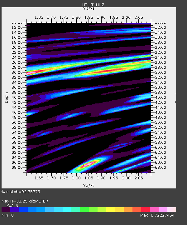
| Estimated Moho Depth: |
30.25 km |
| Estimated Crust Vp/Vs: |
1.60 |
| Assumed Crust Vp: |
6.279 km/s |
| Estimated Crust Vs: |
3.924 km/s |
| Estimated Crust Poisson's Ratio: |
0.18 |
|
| Radial Match: |
92.75779 % |
| Radial Bump: |
400 |
| Transverse Match: |
84.46425 % |
| Transverse Bump: |
400 |
| SOD ConfigId: |
7422571 |
| Insert Time: |
2019-04-22 05:29:20.787 +0000 |
| GWidth: |
2.5 |
| Max Bumps: |
400 |
| Tol: |
0.001 |
|

Signal To Noise
| Channel | StoN | STA | LTA |
| HT:LIT: :HHZ:20160413T14:04:55.120Z | 479.2459 | 3.3793975E-5 | 7.051489E-8 |
| HT:LIT: :HHN:20160413T14:04:55.120Z | 68.13664 | 4.7232484E-6 | 6.932024E-8 |
| HT:LIT: :HHE:20160413T14:04:55.120Z | 391.75244 | 1.5989694E-5 | 4.081581E-8 |
| Arrivals |
| Ps | 3.0 SECOND |
| PpPs | 12 SECOND |
| PsPs/PpSs | 15 SECOND |


