You are here: Home > Network List > JP - Japan Meteorological Agency Seismic Network Stations List
> Station JEW Eniwa > Earthquake Result Viewer
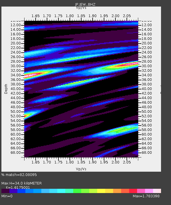
JEW Eniwa - Earthquake Result Viewer
| Earthquake location: |
Myanmar-India Border Region |
| Earthquake latitude/longitude: |
23.1/94.9 |
| Earthquake time(UTC): |
2016/04/13 (104) 13:55:17 GMT |
| Earthquake Depth: |
135 km |
| Earthquake Magnitude: |
6.9 MWB |
| Earthquake Catalog/Contributor: |
NEIC PDE/NEIC COMCAT |
|
| Network: |
JP Japan Meteorological Agency Seismic Network |
| Station: |
JEW Eniwa |
| Lat/Lon: |
42.84 N/141.45 E |
| Elevation: |
185 m |
|
| Distance: |
43.1 deg |
| Az: |
51.409 deg |
| Baz: |
258.033 deg |
| Ray Param: |
0.07227447 |
| Estimated Moho Depth: |
34.0 km |
| Estimated Crust Vp/Vs: |
1.62 |
| Assumed Crust Vp: |
6.468 km/s |
| Estimated Crust Vs: |
3.999 km/s |
| Estimated Crust Poisson's Ratio: |
0.19 |
|
| Radial Match: |
82.08095 % |
| Radial Bump: |
400 |
| Transverse Match: |
71.810265 % |
| Transverse Bump: |
400 |
| SOD ConfigId: |
7422571 |
| Insert Time: |
2019-04-22 05:29:38.153 +0000 |
| GWidth: |
2.5 |
| Max Bumps: |
400 |
| Tol: |
0.001 |
|

Signal To Noise
| Channel | StoN | STA | LTA |
| JP:JEW: :BHZ:20160413T14:02:34.299993Z | 9.204965 | 8.46646E-6 | 9.19771E-7 |
| JP:JEW: :BHN:20160413T14:02:34.299993Z | 1.2761436 | 1.5683039E-6 | 1.2289399E-6 |
| JP:JEW: :BHE:20160413T14:02:34.299993Z | 3.3290493 | 3.550281E-6 | 1.066455E-6 |
| Arrivals |
| Ps | 3.5 SECOND |
| PpPs | 13 SECOND |
| PsPs/PpSs | 16 SECOND |


