You are here: Home > Network List > US - United States National Seismic Network Stations List
> Station EYMN Ely, Minnesota, USA > Earthquake Result Viewer
EYMN Ely, Minnesota, USA - Earthquake Result Viewer

| Earthquake location: |
Tonga Islands |
| Earthquake latitude/longitude: |
-15.0/-173.5 |
| Earthquake time(UTC): |
2004/09/03 (247) 23:18:16 GMT |
| Earthquake Depth: |
10 km |
| Earthquake Magnitude: |
5.2 MB, 5.4 MS, 5.6 MW, 5.5 MW |
| Earthquake Catalog/Contributor: |
WHDF/NEIC |
|
| Network: |
US United States National Seismic Network |
| Station: |
EYMN Ely, Minnesota, USA |
| Lat/Lon: |
47.95 N/91.50 W |
| Elevation: |
475 m |
|
| Distance: |
95.8 deg |
| Az: |
41.998 deg |
| Baz: |
254.07 deg |
| Ray Param: |
0.04069795 |
| Estimated Moho Depth: |
10.0 km |
| Estimated Crust Vp/Vs: |
1.60 |
| Assumed Crust Vp: |
6.467 km/s |
| Estimated Crust Vs: |
4.042 km/s |
| Estimated Crust Poisson's Ratio: |
0.18 |
|
| Radial Match: |
99.72415 % |
| Radial Bump: |
27 |
| Transverse Match: |
99.47182 % |
| Transverse Bump: |
48 |
| SOD ConfigId: |
110165 |
| Insert Time: |
2010-03-05 01:16:22.946 +0000 |
| GWidth: |
2.5 |
| Max Bumps: |
400 |
| Tol: |
0.001 |
|
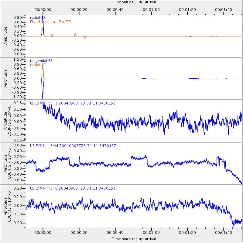
Signal To Noise
| Channel | StoN | STA | LTA |
| US:EYMN: :BHN:20040903T23:31:11.343015Z | 3.5075934 | 2.581706E-7 | 7.360334E-8 |
| US:EYMN: :BHE:20040903T23:31:11.343015Z | 0.93964446 | 3.050192E-8 | 3.2461127E-8 |
| US:EYMN: :BHZ:20040903T23:31:11.343015Z | 0.877259 | 4.7606466E-8 | 5.4267286E-8 |
| Arrivals |
| Ps | 0.9 SECOND |
| PpPs | 3.9 SECOND |
| PsPs/PpSs | 4.9 SECOND |


