You are here: Home > Network List > US - United States National Seismic Network Stations List
> Station EYMN Ely, Minnesota, USA > Earthquake Result Viewer
EYMN Ely, Minnesota, USA - Earthquake Result Viewer
| Earthquake location: |
Tonga Islands |
| Earthquake latitude/longitude: |
-15.3/-173.3 |
| Earthquake time(UTC): |
2004/09/03 (247) 19:04:47 GMT |
| Earthquake Depth: |
10 km |
| Earthquake Magnitude: |
5.5 MB, 5.8 MS, 6.2 MW, 6.0 MW |
| Earthquake Catalog/Contributor: |
WHDF/NEIC |
|
| Network: |
US United States National Seismic Network |
| Station: |
EYMN Ely, Minnesota, USA |
| Lat/Lon: |
47.95 N/91.50 W |
| Elevation: |
475 m |
|
| Distance: |
95.8 deg |
| Az: |
41.987 deg |
| Baz: |
253.825 deg |
| Ray Param: |
0.040679414 |
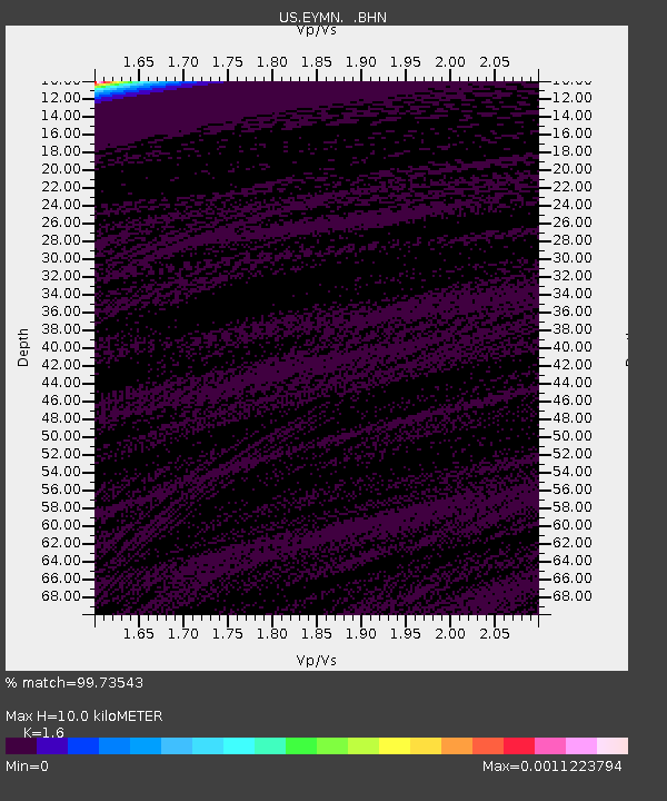
| Estimated Moho Depth: |
10.0 km |
| Estimated Crust Vp/Vs: |
1.60 |
| Assumed Crust Vp: |
6.467 km/s |
| Estimated Crust Vs: |
4.042 km/s |
| Estimated Crust Poisson's Ratio: |
0.18 |
|
| Radial Match: |
99.73543 % |
| Radial Bump: |
28 |
| Transverse Match: |
99.46829 % |
| Transverse Bump: |
36 |
| SOD ConfigId: |
110165 |
| Insert Time: |
2010-03-05 01:16:25.462 +0000 |
| GWidth: |
2.5 |
| Max Bumps: |
400 |
| Tol: |
0.001 |
|

Signal To Noise
| Channel | StoN | STA | LTA |
| US:EYMN: :BHN:20040903T19:17:42.716023Z | 1.0572298 | 1.08915174E-7 | 1.030194E-7 |
| US:EYMN: :BHE:20040903T19:17:42.716023Z | 1.1909795 | 3.318464E-8 | 2.7863317E-8 |
| US:EYMN: :BHZ:20040903T19:17:42.716023Z | 0.8455575 | 5.828011E-8 | 6.8925075E-8 |
| Arrivals |
| Ps | 0.9 SECOND |
| PpPs | 3.9 SECOND |
| PsPs/PpSs | 4.9 SECOND |


