You are here: Home > Network List > CI - Caltech Regional Seismic Network Stations List
> Station BAR Barrett, Tecate, CA, USA > Earthquake Result Viewer
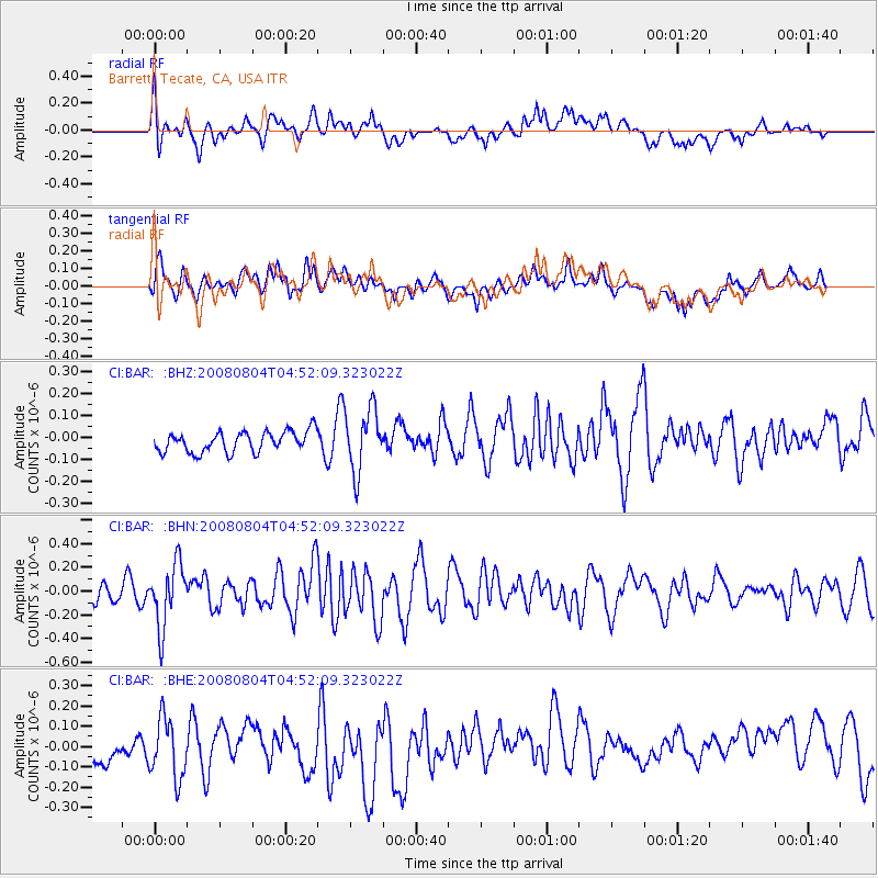
BAR Barrett, Tecate, CA, USA - Earthquake Result Viewer
*The percent match for this event was below the threshold and hence no stack was calculated.
| Earthquake location: |
Kuril Islands |
| Earthquake latitude/longitude: |
49.9/156.4 |
| Earthquake time(UTC): |
2008/08/04 (217) 04:42:14 GMT |
| Earthquake Depth: |
77 km |
| Earthquake Magnitude: |
5.6 MB, 5.8 MW, 5.7 MW |
| Earthquake Catalog/Contributor: |
WHDF/NEIC |
|
| Network: |
CI Caltech Regional Seismic Network |
| Station: |
BAR Barrett, Tecate, CA, USA |
| Lat/Lon: |
32.68 N/116.67 W |
| Elevation: |
521 m |
|
| Distance: |
64.0 deg |
| Az: |
69.575 deg |
| Baz: |
314.005 deg |
| Ray Param: |
$rayparam |
*The percent match for this event was below the threshold and hence was not used in the summary stack. |
|
| Radial Match: |
46.82251 % |
| Radial Bump: |
400 |
| Transverse Match: |
51.50523 % |
| Transverse Bump: |
400 |
| SOD ConfigId: |
2504 |
| Insert Time: |
2010-02-26 00:13:32.040 +0000 |
| GWidth: |
2.5 |
| Max Bumps: |
400 |
| Tol: |
0.001 |
|
Signal To Noise
| Channel | StoN | STA | LTA |
| CI:BAR: :BHN:20080804T04:52:09.323022Z | 2.1162531 | 2.637345E-7 | 1.2462334E-7 |
| CI:BAR: :BHE:20080804T04:52:09.323022Z | 1.2512678 | 1.6780683E-7 | 1.3410944E-7 |
| CI:BAR: :BHZ:20080804T04:52:09.323022Z | 3.0543935 | 1.4343027E-7 | 4.695867E-8 |
| Arrivals |
| Ps | |
| PpPs | |
| PsPs/PpSs | |


