You are here: Home > Network List > PS - Pacific21 Stations List
> Station PATS 6onpei, Micronesia > Earthquake Result Viewer
PATS 6onpei, Micronesia - Earthquake Result Viewer
| Earthquake location: |
Myanmar-India Border Region |
| Earthquake latitude/longitude: |
23.1/94.9 |
| Earthquake time(UTC): |
2016/04/13 (104) 13:55:17 GMT |
| Earthquake Depth: |
135 km |
| Earthquake Magnitude: |
6.9 MWB |
| Earthquake Catalog/Contributor: |
NEIC PDE/NEIC COMCAT |
|
| Network: |
PS Pacific21 |
| Station: |
PATS 6onpei, Micronesia |
| Lat/Lon: |
6.84 N/158.32 E |
| Elevation: |
10 m |
|
| Distance: |
62.9 deg |
| Az: |
94.169 deg |
| Baz: |
292.392 deg |
| Ray Param: |
0.059527762 |
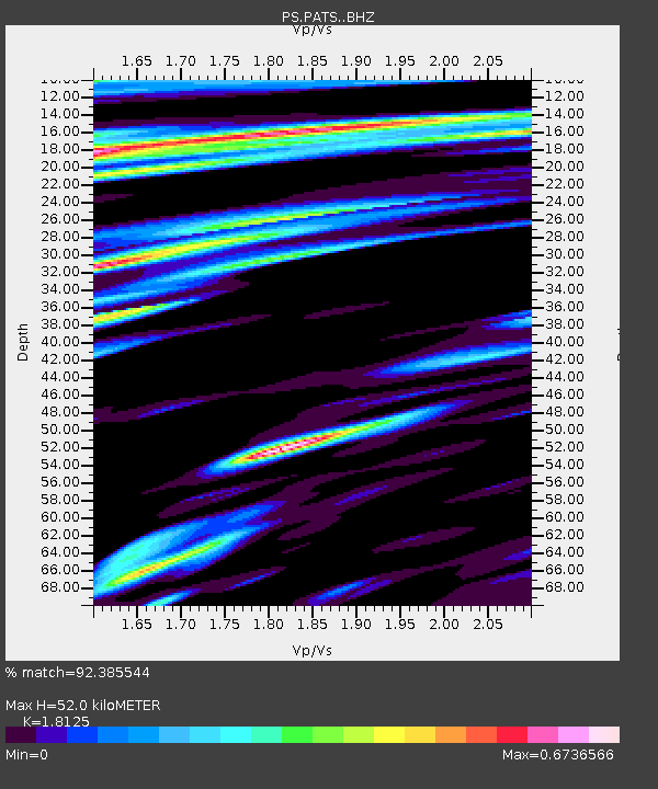
| Estimated Moho Depth: |
52.0 km |
| Estimated Crust Vp/Vs: |
1.81 |
| Assumed Crust Vp: |
4.24 km/s |
| Estimated Crust Vs: |
2.339 km/s |
| Estimated Crust Poisson's Ratio: |
0.28 |
|
| Radial Match: |
92.385544 % |
| Radial Bump: |
400 |
| Transverse Match: |
85.80382 % |
| Transverse Bump: |
400 |
| SOD ConfigId: |
7422571 |
| Insert Time: |
2019-04-22 05:30:38.927 +0000 |
| GWidth: |
2.5 |
| Max Bumps: |
400 |
| Tol: |
0.001 |
|

Signal To Noise
| Channel | StoN | STA | LTA |
| PS:PATS: :BHZ:20160413T14:04:59.111028Z | 26.043085 | 3.1689884E-5 | 1.2168252E-6 |
| PS:PATS: :BHN:20160413T14:04:59.111028Z | 4.0663977 | 6.4775077E-6 | 1.5929352E-6 |
| PS:PATS: :BHE:20160413T14:04:59.111028Z | 7.81728 | 1.0735975E-5 | 1.3733645E-6 |
| Arrivals |
| Ps | 10 SECOND |
| PpPs | 34 SECOND |
| PsPs/PpSs | 44 SECOND |


