You are here: Home > Network List > S - Seismographs in Schools Projects Stations List
> Station AUBSH Beerwah State High School, QLD > Earthquake Result Viewer
AUBSH Beerwah State High School, QLD - Earthquake Result Viewer
| Earthquake location: |
Myanmar-India Border Region |
| Earthquake latitude/longitude: |
23.1/94.9 |
| Earthquake time(UTC): |
2016/04/13 (104) 13:55:17 GMT |
| Earthquake Depth: |
135 km |
| Earthquake Magnitude: |
6.9 MWB |
| Earthquake Catalog/Contributor: |
NEIC PDE/NEIC COMCAT |
|
| Network: |
S Seismographs in Schools Projects |
| Station: |
AUBSH Beerwah State High School, QLD |
| Lat/Lon: |
26.86 S/152.95 E |
| Elevation: |
26 m |
|
| Distance: |
75.0 deg |
| Az: |
128.288 deg |
| Baz: |
306.017 deg |
| Ray Param: |
0.051655434 |
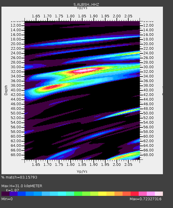
| Estimated Moho Depth: |
31.0 km |
| Estimated Crust Vp/Vs: |
1.87 |
| Assumed Crust Vp: |
6.472 km/s |
| Estimated Crust Vs: |
3.461 km/s |
| Estimated Crust Poisson's Ratio: |
0.30 |
|
| Radial Match: |
83.15793 % |
| Radial Bump: |
370 |
| Transverse Match: |
73.97461 % |
| Transverse Bump: |
400 |
| SOD ConfigId: |
7422571 |
| Insert Time: |
2019-04-22 05:30:50.601 +0000 |
| GWidth: |
2.5 |
| Max Bumps: |
400 |
| Tol: |
0.001 |
|

Signal To Noise
| Channel | StoN | STA | LTA |
| S:AUBSH: :HHZ:20160413T14:06:13.080022Z | 32.426422 | 1.2208501E-5 | 3.7649855E-7 |
| S:AUBSH: :HHN:20160413T14:06:13.080022Z | 4.9480033 | 1.930287E-6 | 3.9011434E-7 |
| S:AUBSH: :HHE:20160413T14:06:13.080022Z | 8.594505 | 5.022763E-6 | 5.844156E-7 |
| Arrivals |
| Ps | 4.3 SECOND |
| PpPs | 13 SECOND |
| PsPs/PpSs | 18 SECOND |


