You are here: Home > Network List > S - Seismographs in Schools Projects Stations List
> Station AUCAS Cummins Area School, SA > Earthquake Result Viewer
AUCAS Cummins Area School, SA - Earthquake Result Viewer
| Earthquake location: |
Myanmar-India Border Region |
| Earthquake latitude/longitude: |
23.1/94.9 |
| Earthquake time(UTC): |
2016/04/13 (104) 13:55:17 GMT |
| Earthquake Depth: |
135 km |
| Earthquake Magnitude: |
6.9 MWB |
| Earthquake Catalog/Contributor: |
NEIC PDE/NEIC COMCAT |
|
| Network: |
S Seismographs in Schools Projects |
| Station: |
AUCAS Cummins Area School, SA |
| Lat/Lon: |
34.26 S/135.72 E |
| Elevation: |
72 m |
|
| Distance: |
69.0 deg |
| Az: |
144.56 deg |
| Baz: |
319.872 deg |
| Ray Param: |
0.05556167 |
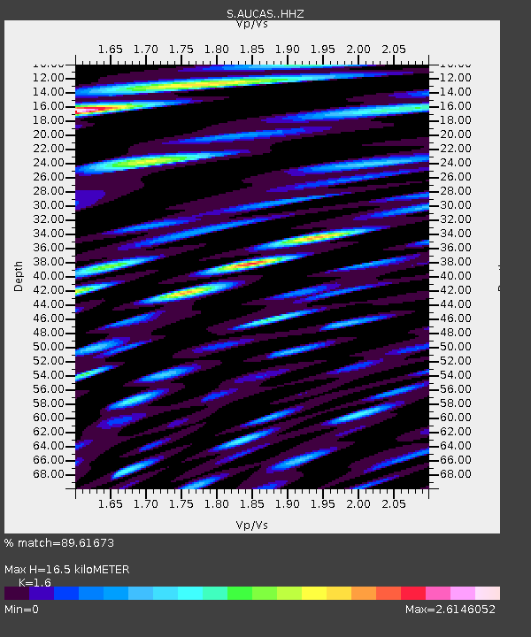
| Estimated Moho Depth: |
16.5 km |
| Estimated Crust Vp/Vs: |
1.60 |
| Assumed Crust Vp: |
6.134 km/s |
| Estimated Crust Vs: |
3.834 km/s |
| Estimated Crust Poisson's Ratio: |
0.18 |
|
| Radial Match: |
89.61673 % |
| Radial Bump: |
400 |
| Transverse Match: |
65.5752 % |
| Transverse Bump: |
400 |
| SOD ConfigId: |
7422571 |
| Insert Time: |
2019-04-22 05:30:51.465 +0000 |
| GWidth: |
2.5 |
| Max Bumps: |
400 |
| Tol: |
0.001 |
|

Signal To Noise
| Channel | StoN | STA | LTA |
| S:AUCAS: :HHZ:20160413T14:05:37.719976Z | 110.4362 | 3.150872E-5 | 2.853115E-7 |
| S:AUCAS: :HHN:20160413T14:05:37.719976Z | 91.85915 | 3.070303E-5 | 3.342403E-7 |
| S:AUCAS: :HHE:20160413T14:05:37.719976Z | 125.85883 | 3.3573753E-5 | 2.667572E-7 |
| Arrivals |
| Ps | 1.7 SECOND |
| PpPs | 6.7 SECOND |
| PsPs/PpSs | 8.4 SECOND |


