You are here: Home > Network List > TA - USArray Transportable Network (new EarthScope stations) Stations List
> Station H23K Yukon River, AK, USA > Earthquake Result Viewer
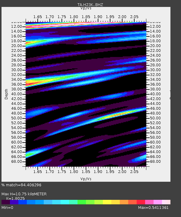
H23K Yukon River, AK, USA - Earthquake Result Viewer
| Earthquake location: |
Myanmar-India Border Region |
| Earthquake latitude/longitude: |
23.1/94.9 |
| Earthquake time(UTC): |
2016/04/13 (104) 13:55:17 GMT |
| Earthquake Depth: |
135 km |
| Earthquake Magnitude: |
6.9 MWB |
| Earthquake Catalog/Contributor: |
NEIC PDE/NEIC COMCAT |
|
| Network: |
TA USArray Transportable Network (new EarthScope stations) |
| Station: |
H23K Yukon River, AK, USA |
| Lat/Lon: |
65.83 N/149.54 W |
| Elevation: |
617 m |
|
| Distance: |
78.9 deg |
| Az: |
22.247 deg |
| Baz: |
302.19 deg |
| Ray Param: |
0.04900417 |
| Estimated Moho Depth: |
10.75 km |
| Estimated Crust Vp/Vs: |
1.80 |
| Assumed Crust Vp: |
6.566 km/s |
| Estimated Crust Vs: |
3.643 km/s |
| Estimated Crust Poisson's Ratio: |
0.28 |
|
| Radial Match: |
94.406296 % |
| Radial Bump: |
400 |
| Transverse Match: |
81.87331 % |
| Transverse Bump: |
400 |
| SOD ConfigId: |
7422571 |
| Insert Time: |
2019-04-22 05:31:24.073 +0000 |
| GWidth: |
2.5 |
| Max Bumps: |
400 |
| Tol: |
0.001 |
|

Signal To Noise
| Channel | StoN | STA | LTA |
| TA:H23K: :BHZ:20160413T14:06:35.34998Z | 23.169125 | 4.3866658E-6 | 1.8933238E-7 |
| TA:H23K: :BHN:20160413T14:06:35.34998Z | 2.9191895 | 6.474127E-7 | 2.2177825E-7 |
| TA:H23K: :BHE:20160413T14:06:35.34998Z | 8.169715 | 1.3693713E-6 | 1.6761554E-7 |
| Arrivals |
| Ps | 1.4 SECOND |
| PpPs | 4.5 SECOND |
| PsPs/PpSs | 5.8 SECOND |


