You are here: Home > Network List > TA - USArray Transportable Network (new EarthScope stations) Stations List
> Station L19K White Mountain, AK, USA > Earthquake Result Viewer
L19K White Mountain, AK, USA - Earthquake Result Viewer
| Earthquake location: |
Myanmar-India Border Region |
| Earthquake latitude/longitude: |
23.1/94.9 |
| Earthquake time(UTC): |
2016/04/13 (104) 13:55:17 GMT |
| Earthquake Depth: |
135 km |
| Earthquake Magnitude: |
6.9 MWB |
| Earthquake Catalog/Contributor: |
NEIC PDE/NEIC COMCAT |
|
| Network: |
TA USArray Transportable Network (new EarthScope stations) |
| Station: |
L19K White Mountain, AK, USA |
| Lat/Lon: |
62.18 N/154.85 W |
| Elevation: |
650 m |
|
| Distance: |
78.7 deg |
| Az: |
26.667 deg |
| Baz: |
298.277 deg |
| Ray Param: |
0.049127817 |
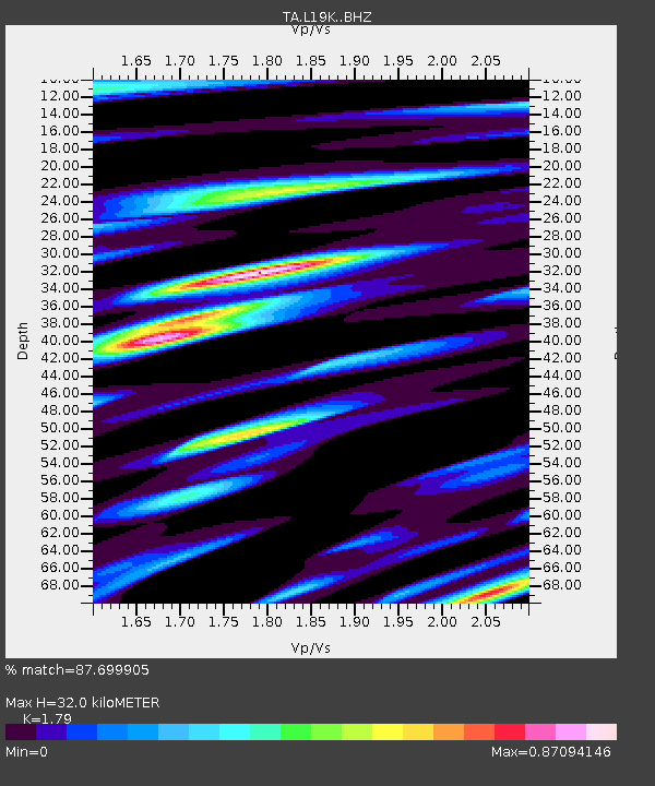
| Estimated Moho Depth: |
32.0 km |
| Estimated Crust Vp/Vs: |
1.79 |
| Assumed Crust Vp: |
6.438 km/s |
| Estimated Crust Vs: |
3.597 km/s |
| Estimated Crust Poisson's Ratio: |
0.27 |
|
| Radial Match: |
87.699905 % |
| Radial Bump: |
400 |
| Transverse Match: |
79.71752 % |
| Transverse Bump: |
400 |
| SOD ConfigId: |
7422571 |
| Insert Time: |
2019-04-22 05:31:34.950 +0000 |
| GWidth: |
2.5 |
| Max Bumps: |
400 |
| Tol: |
0.001 |
|
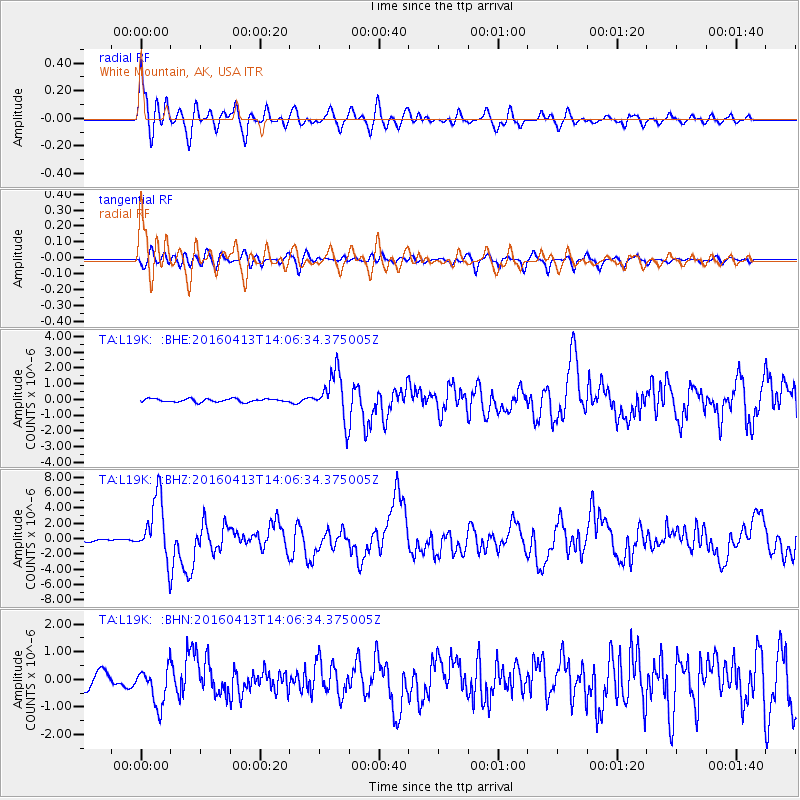
Signal To Noise
| Channel | StoN | STA | LTA |
| TA:L19K: :BHZ:20160413T14:06:34.375005Z | 23.416391 | 4.061872E-6 | 1.7346278E-7 |
| TA:L19K: :BHN:20160413T14:06:34.375005Z | 3.5080137 | 7.0306146E-7 | 2.0041583E-7 |
| TA:L19K: :BHE:20160413T14:06:34.375005Z | 14.093542 | 1.4504972E-6 | 1.0291928E-7 |
| Arrivals |
| Ps | 4.0 SECOND |
| PpPs | 13 SECOND |
| PsPs/PpSs | 18 SECOND |


