You are here: Home > Network List > TA - USArray Transportable Network (new EarthScope stations) Stations List
> Station M24K Tolsona, Glennallen, AK, USA > Earthquake Result Viewer
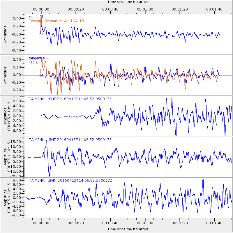
M24K Tolsona, Glennallen, AK, USA - Earthquake Result Viewer
*The percent match for this event was below the threshold and hence no stack was calculated.
| Earthquake location: |
Myanmar-India Border Region |
| Earthquake latitude/longitude: |
23.1/94.9 |
| Earthquake time(UTC): |
2016/04/13 (104) 13:55:17 GMT |
| Earthquake Depth: |
135 km |
| Earthquake Magnitude: |
6.9 MWB |
| Earthquake Catalog/Contributor: |
NEIC PDE/NEIC COMCAT |
|
| Network: |
TA USArray Transportable Network (new EarthScope stations) |
| Station: |
M24K Tolsona, Glennallen, AK, USA |
| Lat/Lon: |
62.11 N/146.18 W |
| Elevation: |
908 m |
|
| Distance: |
82.2 deg |
| Az: |
24.547 deg |
| Baz: |
305.591 deg |
| Ray Param: |
$rayparam |
*The percent match for this event was below the threshold and hence was not used in the summary stack. |
|
| Radial Match: |
76.80801 % |
| Radial Bump: |
400 |
| Transverse Match: |
74.890884 % |
| Transverse Bump: |
400 |
| SOD ConfigId: |
7422571 |
| Insert Time: |
2019-04-22 05:31:41.154 +0000 |
| GWidth: |
2.5 |
| Max Bumps: |
400 |
| Tol: |
0.001 |
|
Signal To Noise
| Channel | StoN | STA | LTA |
| TA:M24K: :BHZ:20160413T14:06:52.950017Z | 20.271744 | 8.390735E-6 | 4.1391286E-7 |
| TA:M24K: :BHN:20160413T14:06:52.950017Z | 3.1197271 | 1.278767E-6 | 4.0989704E-7 |
| TA:M24K: :BHE:20160413T14:06:52.950017Z | 4.4390516 | 1.8110303E-6 | 4.0797687E-7 |
| Arrivals |
| Ps | |
| PpPs | |
| PsPs/PpSs | |


