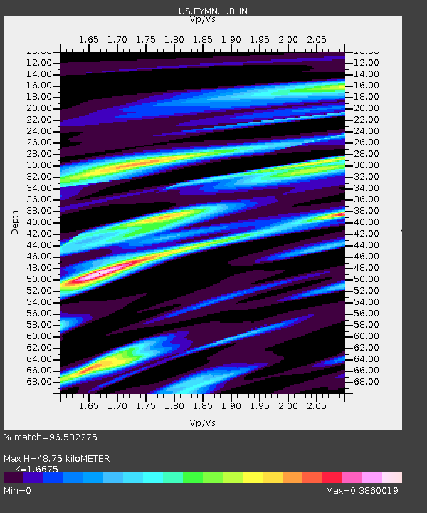
EYMN Ely, Minnesota, USA - Earthquake Result Viewer

Earthquake location: Off East Coast Of Honshu, Japan
Earthquake latitude/longitude: 37.6/142.2
Earthquake time(UTC): 2008/07/19 (201) 02:39:28 GMT
Earthquake Depth: 22 km
Earthquake Magnitude: 6.2 MB, 7.0 MS, 7.0 MW, 6.9 MW
Earthquake Catalog/Contributor: WHDF/NEIC
Network: US United States National Seismic Network
Station: EYMN Ely, Minnesota, USA
Lat/Lon: 47.95 N/91.50 W
Elevation: 475 m
Distance: 82.4 deg
Az: 33.144 deg
Baz: 319.733 deg
Ray Param: 0.046922237
Estimated Moho Depth: 48.75 km
Estimated Crust Vp/Vs: 1.67
Assumed Crust Vp: 6.467 km/s
Estimated Crust Vs: 3.878 km/s
Estimated Crust Poisson's Ratio: 0.22
Radial Match: 96.582275 %
Radial Bump: 336
Transverse Match: 89.31417 %
Transverse Bump: 400
SOD ConfigId: 2504
Insert Time: 2010-03-05 01:16:58.014 +0000
GWidth: 2.5
Max Bumps: 400
Tol: 0.001

Signal To Noise

ChannelStoNSTALTA
US:EYMN: :BHN:20080719T02:51:17.400012Z17.644241.5661913E-68.876501E-8
US:EYMN: :BHE:20080719T02:51:17.400012Z8.5807915.0550557E-75.8911297E-8
US:EYMN: :BHZ:20080719T02:51:17.400012Z9.1626623.747622E-74.090102E-8
Arrivals
Ps5.2 SECOND
PpPs20 SECOND
PsPs/PpSs25 SECOND