You are here: Home > Network List > AV - Alaska Volcano Observatory Stations List
> Station SPCR Ckakachatna River, Mount Spurr, Alaska > Earthquake Result Viewer
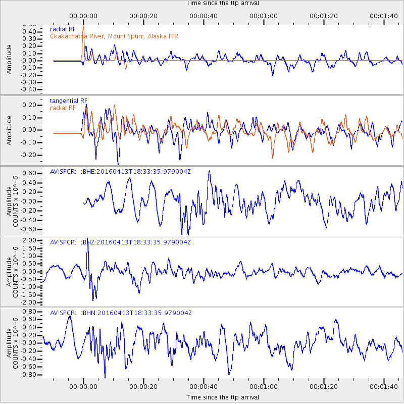
SPCR Ckakachatna River, Mount Spurr, Alaska - Earthquake Result Viewer
*The percent match for this event was below the threshold and hence no stack was calculated.
| Earthquake location: |
Mindanao, Philippines |
| Earthquake latitude/longitude: |
7.8/121.9 |
| Earthquake time(UTC): |
2016/04/13 (104) 18:21:51 GMT |
| Earthquake Depth: |
10 km |
| Earthquake Magnitude: |
5.9 MWB |
| Earthquake Catalog/Contributor: |
NEIC PDE/NEIC COMCAT |
|
| Network: |
AV Alaska Volcano Observatory |
| Station: |
SPCR Ckakachatna River, Mount Spurr, Alaska |
| Lat/Lon: |
61.20 N/152.21 W |
| Elevation: |
984 m |
|
| Distance: |
81.2 deg |
| Az: |
29.258 deg |
| Baz: |
270.188 deg |
| Ray Param: |
$rayparam |
*The percent match for this event was below the threshold and hence was not used in the summary stack. |
|
| Radial Match: |
56.659023 % |
| Radial Bump: |
400 |
| Transverse Match: |
65.381676 % |
| Transverse Bump: |
400 |
| SOD ConfigId: |
7422571 |
| Insert Time: |
2019-04-22 05:34:37.326 +0000 |
| GWidth: |
2.5 |
| Max Bumps: |
400 |
| Tol: |
0.001 |
|
Signal To Noise
| Channel | StoN | STA | LTA |
| AV:SPCR: :BHZ:20160413T18:33:35.979004Z | 3.1292026 | 9.796483E-7 | 3.1306647E-7 |
| AV:SPCR: :BHN:20160413T18:33:35.979004Z | 0.91029453 | 2.5994507E-7 | 2.855615E-7 |
| AV:SPCR: :BHE:20160413T18:33:35.979004Z | 1.4145502 | 3.2111393E-7 | 2.270078E-7 |
| Arrivals |
| Ps | |
| PpPs | |
| PsPs/PpSs | |


