You are here: Home > Network List > CB - China National Seismic Network Stations List
> Station CN2 Changchun,Jilin Province > Earthquake Result Viewer
CN2 Changchun,Jilin Province - Earthquake Result Viewer
| Earthquake location: |
Mindanao, Philippines |
| Earthquake latitude/longitude: |
7.8/121.9 |
| Earthquake time(UTC): |
2016/04/13 (104) 18:21:51 GMT |
| Earthquake Depth: |
10 km |
| Earthquake Magnitude: |
5.9 MWB |
| Earthquake Catalog/Contributor: |
NEIC PDE/NEIC COMCAT |
|
| Network: |
CB China National Seismic Network |
| Station: |
CN2 Changchun,Jilin Province |
| Lat/Lon: |
43.48 N/125.26 E |
| Elevation: |
223 m |
|
| Distance: |
35.6 deg |
| Az: |
4.174 deg |
| Baz: |
185.686 deg |
| Ray Param: |
0.07712887 |
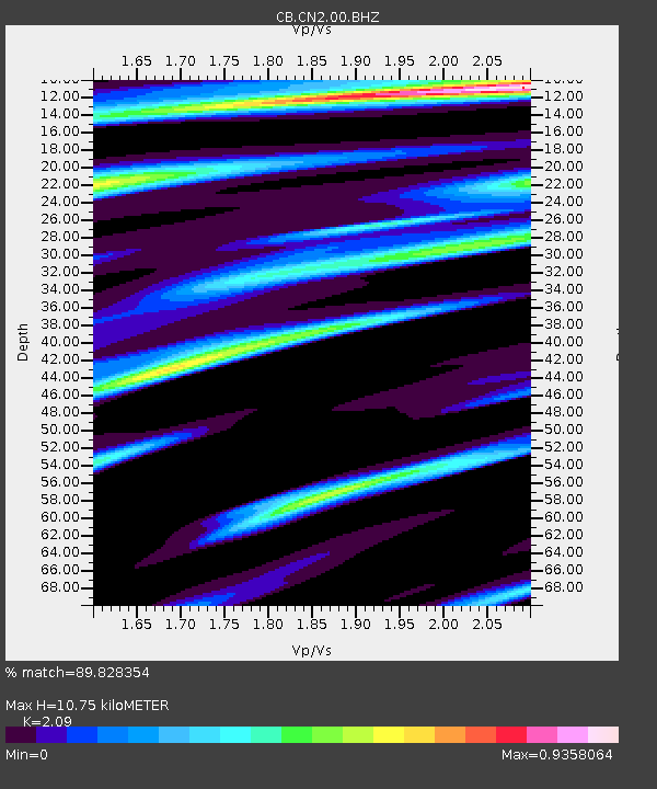
| Estimated Moho Depth: |
10.75 km |
| Estimated Crust Vp/Vs: |
2.09 |
| Assumed Crust Vp: |
6.459 km/s |
| Estimated Crust Vs: |
3.091 km/s |
| Estimated Crust Poisson's Ratio: |
0.35 |
|
| Radial Match: |
89.828354 % |
| Radial Bump: |
400 |
| Transverse Match: |
60.716717 % |
| Transverse Bump: |
400 |
| SOD ConfigId: |
7422571 |
| Insert Time: |
2019-04-22 05:34:39.605 +0000 |
| GWidth: |
2.5 |
| Max Bumps: |
400 |
| Tol: |
0.001 |
|

Signal To Noise
| Channel | StoN | STA | LTA |
| CB:CN2:00:BHZ:20160413T18:28:19.079987Z | 6.786599 | 8.4784625E-7 | 1.2492947E-7 |
| CB:CN2:00:BHN:20160413T18:28:19.079987Z | 7.0827622 | 4.766106E-7 | 6.729163E-8 |
| CB:CN2:00:BHE:20160413T18:28:19.079987Z | 1.2515098 | 1.2219895E-7 | 9.7641234E-8 |
| Arrivals |
| Ps | 1.9 SECOND |
| PpPs | 4.8 SECOND |
| PsPs/PpSs | 6.8 SECOND |


