You are here: Home > Network List > TA - USArray Transportable Network (new EarthScope stations) Stations List
> Station J26L Joseph Creek, AK, USA > Earthquake Result Viewer
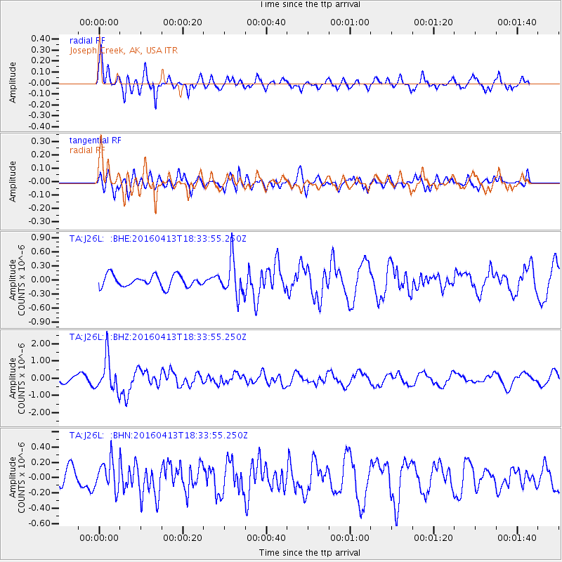
J26L Joseph Creek, AK, USA - Earthquake Result Viewer
*The percent match for this event was below the threshold and hence no stack was calculated.
| Earthquake location: |
Mindanao, Philippines |
| Earthquake latitude/longitude: |
7.8/121.9 |
| Earthquake time(UTC): |
2016/04/13 (104) 18:21:51 GMT |
| Earthquake Depth: |
10 km |
| Earthquake Magnitude: |
5.9 MWB |
| Earthquake Catalog/Contributor: |
NEIC PDE/NEIC COMCAT |
|
| Network: |
TA USArray Transportable Network (new EarthScope stations) |
| Station: |
J26L Joseph Creek, AK, USA |
| Lat/Lon: |
64.50 N/143.56 W |
| Elevation: |
1144 m |
|
| Distance: |
84.9 deg |
| Az: |
25.671 deg |
| Baz: |
277.442 deg |
| Ray Param: |
$rayparam |
*The percent match for this event was below the threshold and hence was not used in the summary stack. |
|
| Radial Match: |
75.84121 % |
| Radial Bump: |
344 |
| Transverse Match: |
58.88984 % |
| Transverse Bump: |
400 |
| SOD ConfigId: |
7422571 |
| Insert Time: |
2019-04-22 05:36:56.306 +0000 |
| GWidth: |
2.5 |
| Max Bumps: |
400 |
| Tol: |
0.001 |
|
Signal To Noise
| Channel | StoN | STA | LTA |
| TA:J26L: :BHZ:20160413T18:33:55.250Z | 4.848079 | 9.982631E-7 | 2.05909E-7 |
| TA:J26L: :BHN:20160413T18:33:55.250Z | 1.4973881 | 1.9112773E-7 | 1.2764073E-7 |
| TA:J26L: :BHE:20160413T18:33:55.250Z | 3.1017172 | 3.8260083E-7 | 1.233513E-7 |
| Arrivals |
| Ps | |
| PpPs | |
| PsPs/PpSs | |


