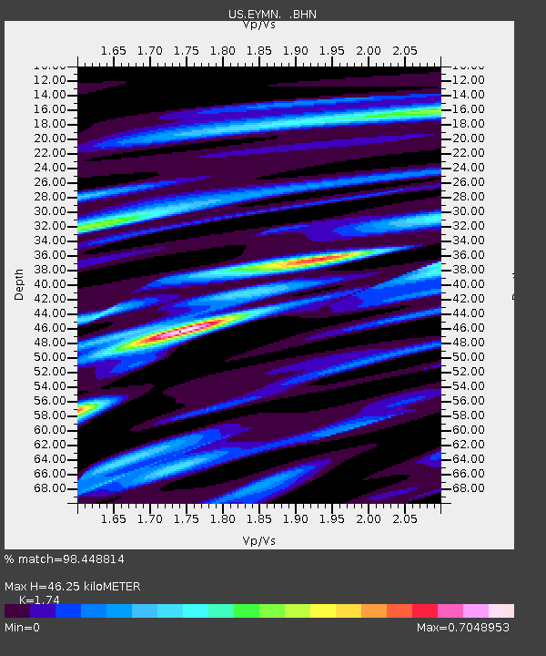
EYMN Ely, Minnesota, USA - Earthquake Result Viewer

Earthquake location: Near West Coast Of Honshu, Japan
Earthquake latitude/longitude: 37.5/138.4
Earthquake time(UTC): 2007/07/16 (197) 01:13:22 GMT
Earthquake Depth: 12 km
Earthquake Magnitude: 6.5 MB, 6.4 MS, 6.6 MW, 6.5 MW
Earthquake Catalog/Contributor: WHDF/NEIC
Network: US United States National Seismic Network
Station: EYMN Ely, Minnesota, USA
Lat/Lon: 47.95 N/91.50 W
Elevation: 475 m
Distance: 84.0 deg
Az: 31.161 deg
Baz: 322.278 deg
Ray Param: 0.045809437
Estimated Moho Depth: 46.25 km
Estimated Crust Vp/Vs: 1.74
Assumed Crust Vp: 6.467 km/s
Estimated Crust Vs: 3.716 km/s
Estimated Crust Poisson's Ratio: 0.25
Radial Match: 98.448814 %
Radial Bump: 294
Transverse Match: 95.14 %
Transverse Bump: 400
SOD ConfigId: 2564
Insert Time: 2010-03-05 01:18:04.216 +0000
GWidth: 2.5
Max Bumps: 400
Tol: 0.001

Signal To Noise

ChannelStoNSTALTA
US:EYMN: :BHN:20070716T01:25:20.799016Z19.8142471.1626627E-65.867812E-8
US:EYMN: :BHE:20070716T01:25:20.799016Z14.0096757.562734E-75.3982223E-8
US:EYMN: :BHZ:20070716T01:25:20.799016Z47.615693.6213728E-67.605419E-8
Arrivals
Ps5.4 SECOND
PpPs19 SECOND
PsPs/PpSs25 SECOND