You are here: Home > Network List > G - GEOSCOPE Stations List
> Station ROCAM Leguat Reserve, Rodrigues Island, Republic of Mauritius > Earthquake Result Viewer
ROCAM Leguat Reserve, Rodrigues Island, Republic of Mauritius - Earthquake Result Viewer
| Earthquake location: |
Irian Jaya, Indonesia |
| Earthquake latitude/longitude: |
-2.7/138.5 |
| Earthquake time(UTC): |
2015/07/27 (208) 21:41:22 GMT |
| Earthquake Depth: |
53 km |
| Earthquake Magnitude: |
7.0 MWP, 7.0 MI |
| Earthquake Catalog/Contributor: |
NEIC PDE/NEIC COMCAT |
|
| Network: |
G GEOSCOPE |
| Station: |
ROCAM Leguat Reserve, Rodrigues Island, Republic of Mauritius |
| Lat/Lon: |
19.76 S/63.37 E |
| Elevation: |
52 m |
|
| Distance: |
75.1 deg |
| Az: |
250.387 deg |
| Baz: |
87.488 deg |
| Ray Param: |
0.05180595 |
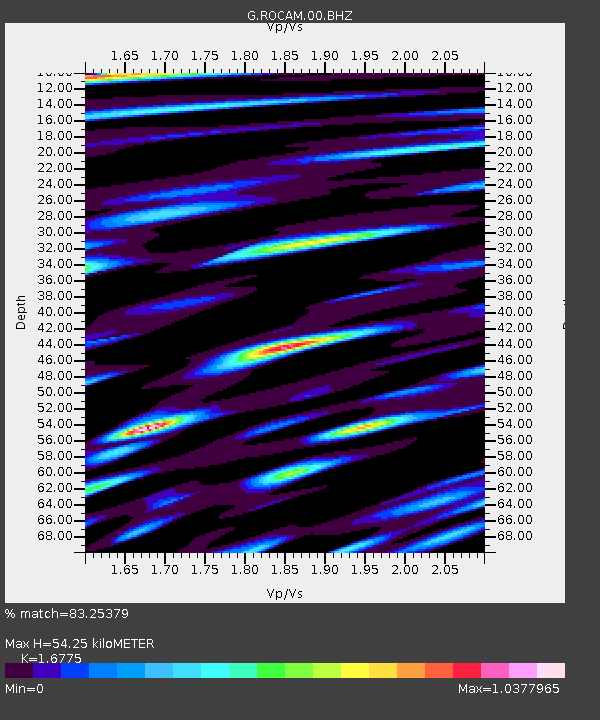
| Estimated Moho Depth: |
54.25 km |
| Estimated Crust Vp/Vs: |
1.68 |
| Assumed Crust Vp: |
4.802 km/s |
| Estimated Crust Vs: |
2.863 km/s |
| Estimated Crust Poisson's Ratio: |
0.22 |
|
| Radial Match: |
83.25379 % |
| Radial Bump: |
400 |
| Transverse Match: |
88.55045 % |
| Transverse Bump: |
381 |
| SOD ConfigId: |
1085051 |
| Insert Time: |
2015-08-10 22:33:27.796 +0000 |
| GWidth: |
2.5 |
| Max Bumps: |
400 |
| Tol: |
0.001 |
|

Signal To Noise
| Channel | StoN | STA | LTA |
| G:ROCAM:00:BHZ:20150727T21:52:27.850027Z | 3.698421 | 5.8263417E-6 | 1.5753592E-6 |
| G:ROCAM:00:BHN:20150727T21:52:27.850027Z | 1.8683431 | 2.4200406E-6 | 1.295287E-6 |
| G:ROCAM:00:BHE:20150727T21:52:27.850027Z | 1.3635044 | 2.0356608E-6 | 1.4929624E-6 |
| Arrivals |
| Ps | 7.8 SECOND |
| PpPs | 30 SECOND |
| PsPs/PpSs | 37 SECOND |


