You are here: Home > Network List > KN - Kyrgyz Seismic Telemetry Network Stations List
> Station TKM2 - > Earthquake Result Viewer
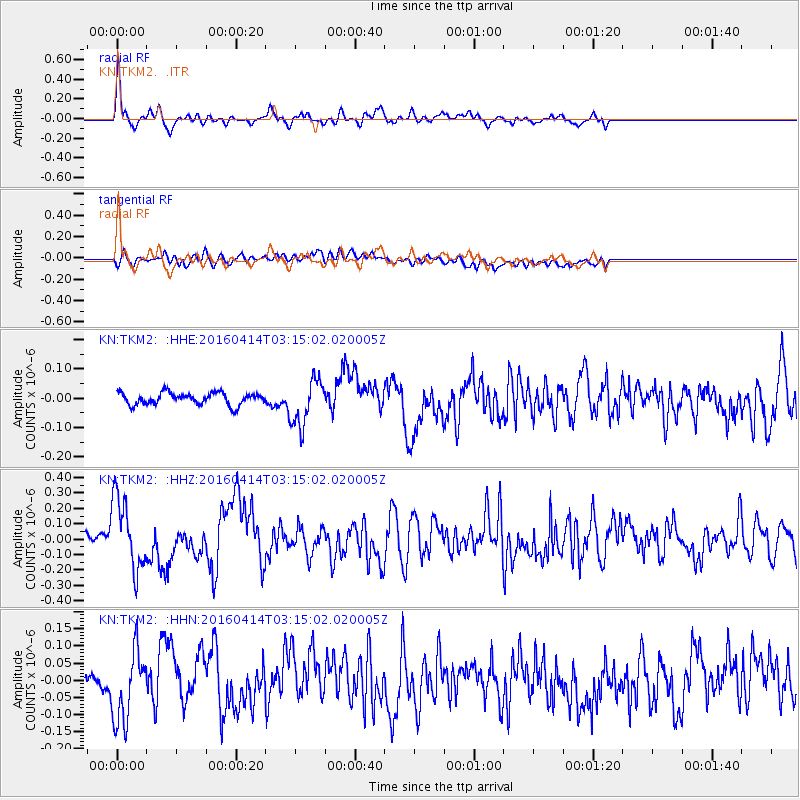
TKM2 - - Earthquake Result Viewer
*The percent match for this event was below the threshold and hence no stack was calculated.
| Earthquake location: |
Near East Coast Of Kamchatka |
| Earthquake latitude/longitude: |
53.9/160.7 |
| Earthquake time(UTC): |
2016/04/14 (105) 03:06:09 GMT |
| Earthquake Depth: |
36 km |
| Earthquake Magnitude: |
5.8 MWW, 5.7 MWB, 5.8 MWC |
| Earthquake Catalog/Contributor: |
NEIC PDE/NEIC COMCAT |
|
| Network: |
KN Kyrgyz Seismic Telemetry Network |
| Station: |
TKM2 - |
| Lat/Lon: |
42.92 N/75.60 E |
| Elevation: |
2020 m |
|
| Distance: |
54.3 deg |
| Az: |
295.678 deg |
| Baz: |
46.622 deg |
| Ray Param: |
$rayparam |
*The percent match for this event was below the threshold and hence was not used in the summary stack. |
|
| Radial Match: |
69.35743 % |
| Radial Bump: |
400 |
| Transverse Match: |
45.28935 % |
| Transverse Bump: |
400 |
| SOD ConfigId: |
7422571 |
| Insert Time: |
2019-04-22 05:43:47.163 +0000 |
| GWidth: |
2.5 |
| Max Bumps: |
400 |
| Tol: |
0.001 |
|
Signal To Noise
| Channel | StoN | STA | LTA |
| KN:TKM2: :HHZ:20160414T03:15:02.020005Z | 4.7326107 | 2.3190843E-7 | 4.9002217E-8 |
| KN:TKM2: :HHN:20160414T03:15:02.020005Z | 3.1762424 | 1.0201779E-7 | 3.2119022E-8 |
| KN:TKM2: :HHE:20160414T03:15:02.020005Z | 3.8757756 | 8.028756E-8 | 2.0715225E-8 |
| Arrivals |
| Ps | |
| PpPs | |
| PsPs/PpSs | |


