You are here: Home > Network List > CI - Caltech Regional Seismic Network Stations List
> Station BAR Barrett, Tecate, CA, USA > Earthquake Result Viewer
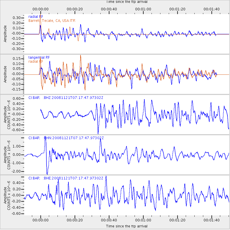
BAR Barrett, Tecate, CA, USA - Earthquake Result Viewer
*The percent match for this event was below the threshold and hence no stack was calculated.
| Earthquake location: |
Solomon Islands |
| Earthquake latitude/longitude: |
-8.9/159.6 |
| Earthquake time(UTC): |
2008/11/21 (326) 07:05:34 GMT |
| Earthquake Depth: |
118 km |
| Earthquake Magnitude: |
6.0 MB, 6.1 MW, 6.0 MW |
| Earthquake Catalog/Contributor: |
WHDF/NEIC |
|
| Network: |
CI Caltech Regional Seismic Network |
| Station: |
BAR Barrett, Tecate, CA, USA |
| Lat/Lon: |
32.68 N/116.67 W |
| Elevation: |
521 m |
|
| Distance: |
89.6 deg |
| Az: |
56.971 deg |
| Baz: |
259.171 deg |
| Ray Param: |
$rayparam |
*The percent match for this event was below the threshold and hence was not used in the summary stack. |
|
| Radial Match: |
76.33481 % |
| Radial Bump: |
400 |
| Transverse Match: |
57.645477 % |
| Transverse Bump: |
400 |
| SOD ConfigId: |
2658 |
| Insert Time: |
2010-02-26 00:13:41.548 +0000 |
| GWidth: |
2.5 |
| Max Bumps: |
400 |
| Tol: |
0.001 |
|
Signal To Noise
| Channel | StoN | STA | LTA |
| CI:BAR: :BHN:20081121T07:17:47.97302Z | 6.852984 | 1.1736952E-6 | 1.7126776E-7 |
| CI:BAR: :BHE:20081121T07:17:47.97302Z | 1.5939674 | 1.1367117E-7 | 7.131336E-8 |
| CI:BAR: :BHZ:20081121T07:17:47.97302Z | 3.2544746 | 2.6257152E-7 | 8.068015E-8 |
| Arrivals |
| Ps | |
| PpPs | |
| PsPs/PpSs | |


