You are here: Home > Network List > N4 - Central and EAstern US Network Stations List
> Station T45B Paducah, KY, USA > Earthquake Result Viewer
T45B Paducah, KY, USA - Earthquake Result Viewer
| Earthquake location: |
Near East Coast Of Kamchatka |
| Earthquake latitude/longitude: |
53.9/160.7 |
| Earthquake time(UTC): |
2016/04/14 (105) 03:06:09 GMT |
| Earthquake Depth: |
36 km |
| Earthquake Magnitude: |
5.8 MWW, 5.7 MWB, 5.8 MWC |
| Earthquake Catalog/Contributor: |
NEIC PDE/NEIC COMCAT |
|
| Network: |
N4 Central and EAstern US Network |
| Station: |
T45B Paducah, KY, USA |
| Lat/Lon: |
37.02 N/88.65 W |
| Elevation: |
136 m |
|
| Distance: |
71.6 deg |
| Az: |
52.153 deg |
| Baz: |
324.236 deg |
| Ray Param: |
0.054178786 |
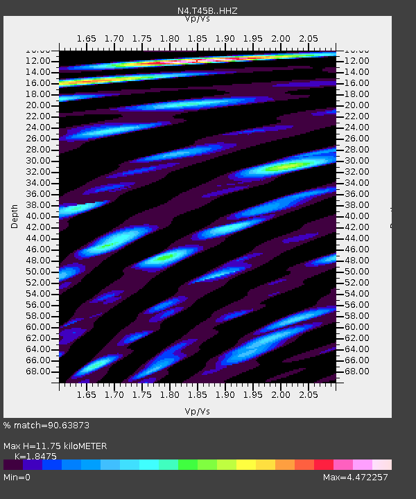
| Estimated Moho Depth: |
11.75 km |
| Estimated Crust Vp/Vs: |
1.85 |
| Assumed Crust Vp: |
6.444 km/s |
| Estimated Crust Vs: |
3.488 km/s |
| Estimated Crust Poisson's Ratio: |
0.29 |
|
| Radial Match: |
90.63873 % |
| Radial Bump: |
400 |
| Transverse Match: |
77.56867 % |
| Transverse Bump: |
400 |
| SOD ConfigId: |
7422571 |
| Insert Time: |
2019-04-22 05:46:07.775 +0000 |
| GWidth: |
2.5 |
| Max Bumps: |
400 |
| Tol: |
0.001 |
|

Signal To Noise
| Channel | StoN | STA | LTA |
| N4:T45B: :HHZ:20160414T03:16:56.199998Z | 9.694044 | 1.1838436E-6 | 1.2212071E-7 |
| N4:T45B: :HHN:20160414T03:16:56.199998Z | 6.955442 | 1.5253303E-6 | 2.1930026E-7 |
| N4:T45B: :HHE:20160414T03:16:56.199998Z | 6.289139 | 1.0695309E-6 | 1.7005998E-7 |
| Arrivals |
| Ps | 1.6 SECOND |
| PpPs | 5.0 SECOND |
| PsPs/PpSs | 6.6 SECOND |


