You are here: Home > Network List > CI - Caltech Regional Seismic Network Stations List
> Station BAR Barrett, Tecate, CA, USA > Earthquake Result Viewer
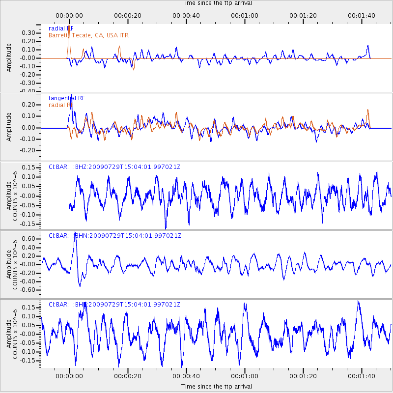
BAR Barrett, Tecate, CA, USA - Earthquake Result Viewer
*The percent match for this event was below the threshold and hence no stack was calculated.
| Earthquake location: |
Volcano Islands, Japan Region |
| Earthquake latitude/longitude: |
22.6/143.3 |
| Earthquake time(UTC): |
2009/07/29 (210) 14:52:08 GMT |
| Earthquake Depth: |
140 km |
| Earthquake Magnitude: |
5.5 MW, 5.2 MB, 5.4 MW |
| Earthquake Catalog/Contributor: |
WHDF/NEIC |
|
| Network: |
CI Caltech Regional Seismic Network |
| Station: |
BAR Barrett, Tecate, CA, USA |
| Lat/Lon: |
32.68 N/116.67 W |
| Elevation: |
521 m |
|
| Distance: |
86.1 deg |
| Az: |
56.34 deg |
| Baz: |
294.182 deg |
| Ray Param: |
$rayparam |
*The percent match for this event was below the threshold and hence was not used in the summary stack. |
|
| Radial Match: |
44.32761 % |
| Radial Bump: |
400 |
| Transverse Match: |
64.894005 % |
| Transverse Bump: |
400 |
| SOD ConfigId: |
2622 |
| Insert Time: |
2010-02-26 00:13:43.932 +0000 |
| GWidth: |
2.5 |
| Max Bumps: |
400 |
| Tol: |
0.001 |
|
Signal To Noise
| Channel | StoN | STA | LTA |
| CI:BAR: :BHN:20090729T15:04:01.997021Z | 3.714465 | 3.6170528E-7 | 9.737749E-8 |
| CI:BAR: :BHE:20090729T15:04:01.997021Z | 0.9287832 | 8.4469704E-8 | 9.0946635E-8 |
| CI:BAR: :BHZ:20090729T15:04:01.997021Z | 1.382281 | 7.1651925E-8 | 5.1836004E-8 |
| Arrivals |
| Ps | |
| PpPs | |
| PsPs/PpSs | |


