You are here: Home > Network List > XL12 - Hangay Dome, Mongolia Stations List
> Station HV19 HV19 > Earthquake Result Viewer
HV19 HV19 - Earthquake Result Viewer
| Earthquake location: |
Near East Coast Of Kamchatka |
| Earthquake latitude/longitude: |
53.9/160.7 |
| Earthquake time(UTC): |
2016/04/14 (105) 03:06:09 GMT |
| Earthquake Depth: |
36 km |
| Earthquake Magnitude: |
5.8 MWW, 5.7 MWB, 5.8 MWC |
| Earthquake Catalog/Contributor: |
NEIC PDE/NEIC COMCAT |
|
| Network: |
XL Hangay Dome, Mongolia |
| Station: |
HV19 HV19 |
| Lat/Lon: |
50.98 N/100.73 E |
| Elevation: |
1683 m |
|
| Distance: |
35.8 deg |
| Az: |
290.485 deg |
| Baz: |
61.395 deg |
| Ray Param: |
0.076976605 |
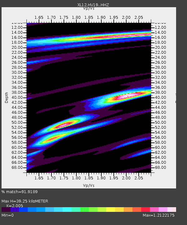
| Estimated Moho Depth: |
39.25 km |
| Estimated Crust Vp/Vs: |
2.01 |
| Assumed Crust Vp: |
6.419 km/s |
| Estimated Crust Vs: |
3.202 km/s |
| Estimated Crust Poisson's Ratio: |
0.33 |
|
| Radial Match: |
91.9189 % |
| Radial Bump: |
335 |
| Transverse Match: |
70.64684 % |
| Transverse Bump: |
400 |
| SOD ConfigId: |
7422571 |
| Insert Time: |
2019-04-22 05:50:58.330 +0000 |
| GWidth: |
2.5 |
| Max Bumps: |
400 |
| Tol: |
0.001 |
|

Signal To Noise
| Channel | StoN | STA | LTA |
| XL:HV19: :HHZ:20160414T03:12:35.120011Z | 9.376361 | 3.6772872E-7 | 3.9218705E-8 |
| XL:HV19: :HHN:20160414T03:12:35.120011Z | 5.539666 | 1.4864325E-7 | 2.6832529E-8 |
| XL:HV19: :HHE:20160414T03:12:35.120011Z | 7.139001 | 2.1773718E-7 | 3.0499674E-8 |
| Arrivals |
| Ps | 6.6 SECOND |
| PpPs | 17 SECOND |
| PsPs/PpSs | 24 SECOND |


